
Holmes Run Trail facts for kids
Quick facts for kids Holmes Run Trail |
|
|---|---|
| Length | 5 miles (8.0 km) |
| Location | Alexandria, Virginia and Fairfax County, Virginia |
| Trailheads | Cameron Run Regional Park, Lake Barcroft, Roundtree Park |
| Use | cycling, pedestrians |
| Cycling details | |
| Surface | asphalt and stonedust |
| Holmes Run Trail Map | |

Map of the southern section of the Holmes Run Trail
|
|
The Holmes Run Trail is a fun path for walking and biking. It goes through parks in Alexandria, Virginia and Fairfax County, Virginia. The trail follows a stream called Holmes Run. It starts near Cameron Run and goes all the way to Annandale Road.
This trail has two main parts. They are separated by Lake Barcroft. The path often runs right next to the water. You'll cross many small bridges along the way. Some bridges are very close to the stream's surface.
The part of the trail in Alexandria is about 2.6 miles (4.2 km) long. It starts at Eisenhower Avenue near Cameron Run Regional Park. This section ends at the border between Alexandria and Fairfax County. The Fairfax County part is about 1.2 miles (1.9 km) long. It goes from the border to Columbia Pike. These two parts together make up the southern section, which is about 3.8-mile-long (6.1 km).
There's also a northern section of the trail. It is about 1.2 miles (1.9 km) long and is only in Fairfax County. Parts of the trail are paved with asphalt. Other parts have a surface called stonedust, which is like packed gravel.
Contents
Trail History: How It Was Built
The idea for the Holmes Run Trail started a long time ago. It was first planned in the 1970s. This was part of a big project to control floods in the Cameron Run Valley. The first 1.5 miles (2.4 km) of the trail were built in the early 1980s. This part went from Cameron Run to Dora Kelly Nature Park.
Fairfax County began to make the trail longer in 2006. They added another 1.5 miles (2.4 km) from Glen Hills Park to Columbia Pike. This part was finished in 2007. However, the two sections didn't connect right away because Holmes Run was in the way.
Later, more connections were added. In 2012, Alexandria built a special path under Eisenhower Avenue. This connected the Holmes Run Trail to the Eisenhower Avenue Trail. In 2013, a low water crossing was built near Chambliss Street. This finally connected the two southern parts of the trail. In 2018, a new bridge was built over Holmes Run at N. Ripley Street. This bridge replaced an older low water crossing.
Exploring the Trail Route
The main southern part of the Holmes Run Trail is about 3.8-mile-long (6.1 km). It starts near Cameron Run Regional Park and the Great Waves Waterpark in Alexandria. Right at the beginning, you can connect to the Eisenhower Avenue Trail. This trail goes east to the Hoffman Town Center and the Eisenhower Avenue station on the Blue Line subway.
You'll go under Eisenhower Avenue through a special path. Then, the Holmes Run Trail follows Cameron Run. It passes under the Blue Line and three railroad bridges. After that, you enter Ben Brenman Park. Here, Holmes Run and Backlick Run meet to form Cameron Run.
The trail continues through Ben Brenman Park. You'll find another paved trail that crosses Holmes Run. This side trail goes west through Ben Brenman Park and Cameron Station Linear Park. It leads to Armistead Boothe Park, which is next to Samuel W. Tucker Elementary School.
After this side trail, the Holmes Run Trail keeps going northwest. It passes under Duke Street. Then, it goes through Holmes Run Park. You'll see the Charles Beatley Bridge, which crosses the stream. This bridge connects the trail to North Pickett Street.
The trail then goes through Brookvalley Park. Here, it crosses to the west side of the stream. You'll pass under North Van Dorn Street and Interstate 395. After that, the trail crosses North Beauregard Street and goes back to the east side of the stream.
The path continues through wooded areas in Dora Kelley Nature Park. It reaches North Chambliss Street, where a bridge takes you over the stream to its west side. Soon after, you enter Fairfax County and go through Glen Hills Park.
After Glen Hills Park, the southern trail continues northwest. It passes the Parklawn Pool. The trail then crosses Holmes Run five more times in Holmes Run Stream Valley Park and Lillian Carey Park. It ends on the east side of the stream, connecting to the Columbia Pike Trail.
The northern section of the trail is separate from the southern part by Lake Barcroft. This part is about 1.2-mile-long (1.9 km). It starts at the end of Sprucedale Drive. The trail first goes east, then turns north. It crosses Holmes Run on a bridge to reach the north side. Then, it travels northwest through Holmes Run Stream Valley Park. This section ends at Hockett Street, which connects to Annandale Road. Most of this northern section has a stone dust surface, though some parts are paved.
Trail Safety: Flooding Information
It's important to check the weather before you visit the Holmes Run Trail. Holmes Run is part of a larger water system. It helps carry floodwaters away, especially during heavy rain.
Because parts of the trail are very close to the water, they can get covered by water. This happens often during and after rainstorms. The section that goes under Interstate 395 is especially known for flooding. Always be careful and aware of water levels!
Images for kids
-
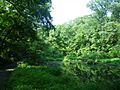
A part of the trail next to a pond.
-
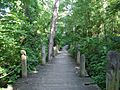
The trail looking south from Beauregard Street.
-
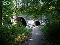
The entrance to the tunnel under I-395.
-
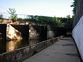
This section of the trail often gets flooded.
-
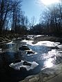
Holmes Run during the winter season.


