Cameron Run facts for kids
Quick facts for kids Cameron Run |
|
|---|---|

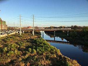
Cameron Run seen from the Yellow Line of the Washington Metro, looking downriver towards the Potomac
|
|
| Country | United States |
| Location | Virginia |
| Physical characteristics | |
| River mouth | Hunting Creek 38°47′31″N 77°03′22″W / 38.792°N 77.056°W |
| Length | 3.0 miles (4.8 km) |
Cameron Run is a 3.0-mile-long (4.8 km) stream in Virginia, United States. It's like a smaller river that flows into a bigger one. Cameron Run eventually joins Hunting Creek, which then flows into the famous Potomac River.
This stream begins where two other streams, Backlick Run and Holmes Run, meet. From there, it flows eastward. For a while, it forms the border between Fairfax County and the city of Alexandria.
Near Eisenhower Avenue, parts of Cameron Run have been changed by people. Its path has been made straighter and deeper to help control water flow. The last mile or so of the stream is affected by the ocean's tides. In the past, during colonial times, boats could travel on this part of the stream.
A fun place called Cameron Run Regional Park, which has a water park, is located along the stream. Cameron Run is part of a larger area called the Cameron Run Watershed. A watershed is all the land where water drains into a specific river or stream. This watershed covers about 44 square miles (110 km2) in Northern Virginia.
Why Cameron Run Floods Sometimes
Cameron Run has flooded several times, including in 2000 and 2006. These floods caused damage to low-lying areas, especially in the Huntington neighborhood.
What Causes Flooding in Cameron Run?
One reason for more flooding is that more buildings and roads have been built in the watershed. When it rains, water runs off these hard surfaces faster, increasing the amount of water flowing into the stream.
Also, too much dirt and sand, called sediment, has built up in the stream. Some of this sediment came from the construction of the Woodrow Wilson Bridge project, which started in 1999. This sediment makes the stream's channel shallower, so it can't hold as much water. When heavy rains come, the water overflows the banks.
Working to Prevent Future Floods
Local governments and the U.S. Army Corps of Engineers are working together to find solutions. The U.S. Army Corps of Engineers is a government agency that helps manage water resources and prevent floods.
In November 2012, people in Fairfax County voted to approve $30 million to help stop flooding. This money was used to build a levee and a pump station. A levee is a wall built along a river to prevent it from overflowing. A pump station helps move water away from flooded areas. Construction on this flood prevention system began in 2014 and was completed in 2019.
 | John T. Biggers |
 | Thomas Blackshear |
 | Mark Bradford |
 | Beverly Buchanan |


