
Holyoke Canal System facts for kids
Quick facts for kids |
|
|
Holyoke Canal System
|
|
.jpg)
Holyoke Canal System
|
|
| Location | Holyoke, Massachusetts |
|---|---|
| Built | 1847 |
| Architect | Philander Anderson, C.E. |
| NRHP reference No. | 80000473 |
| Added to NRHP | December 3, 1980 |
The Holyoke Canal System is a network of special waterways in Holyoke, Massachusetts. These canals were built to use the power of water from the Connecticut River. The system has three main parts, each at a different height: the First Level Canal, the Second Level Canal, and the Third Level Canal.
Built between 1847 and 1892, the Holyoke Canal System is famous for its role in inventing important tools. It helped develop the Venturi meter, which was the first way to accurately measure large amounts of water flow. It also led to the McCormick-Holyoke Turbine, a water wheel that was much more efficient than older ones, doubling their power output. Because of these inventions, the Canal System is recognized as a Historic Mechanical Engineering Landmark.
History of the Canals

The idea for Holyoke's canals started in 1827. A company called Hadley Falls Company wanted to make cotton cloth using water-powered machines. They used a small dam on the Connecticut River to get water for their factories.
The canals we see today began in 1848. Engineers measured the river and found it had enough power for 450 mills! A new company was formed with a lot of money to build a manufacturing city. Over the next 10 years, they built the main dam and the canal system. They also planned out areas for factories, shops, and homes.

In 1848, the first dam was built across the Connecticut River. It was about 1,000 feet (300 meters) long and made of timber. But it broke just hours after it was finished! A second timber dam was built, and later, in 1900, a stronger granite dam replaced it. Workers dug the early canals by hand, using picks and shovels, with horses helping to pull away the dirt. Building the canals continued until 1892.
In 1859, a new company, the Holyoke Water Power Company, took over the system. They bought the dam, the gates, and about 2.5 miles (4 kilometers) of canals. This company helped Holyoke grow, and many large factories were built nearby. Water power from the canals turned big water wheels. These wheels then used gears, shafts, and belts to send power to the machines inside the factories.
The canals also started making electricity! On October 14, 1884, they produced electricity for the city for the first time. This was done using a generator connected to a water wheel. Later, a bigger power plant was built that used both water and steam.
Today, the City of Holyoke owns the canal system. Its Gas and Electric Department runs it. People have also worked to make the canals a nice place for walking. In 2015, new sidewalks were finished, creating the "Canal Walk." This path connects the downtown area to the new train station.
How the Canals Work

The Holyoke Canal System is about 4.5 miles (7.2 kilometers) long and has three different levels. Water flows from the highest level down to the lowest, generating electricity as it goes, before returning to the river.
The First Level Canal is where the water first enters the system. It has 12 large gates that control the water flow. Each gate is huge, weighing over four tons! This canal starts about 140 feet (43 meters) wide and 22 feet (6.7 meters) deep. It flows south for more than a mile, supplying water to the factories on the upper level.
The Second Level Canal runs next to the First Level, but it's about 400 feet (120 meters) to the east. It starts at the south end and flows north for over a mile. This canal is about 140 feet (43 meters) wide at first, then gets a bit narrower. Its average depth is about 15 feet (4.6 meters).
The Third Level Canal is below the Second Level, about 12 feet (3.7 meters) lower. It stretches for about 3,550 feet (1,080 meters). This canal is usually about 100 feet (30 meters) wide and 10 feet (3 meters) deep. Its height above the river changes, but it's usually between 23 and 28 feet (7 to 8.5 meters).
Gallery
-
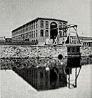
The Holyoke Testing Flume in 1895. This is where the McCormick-Holyoke Turbine was developed.
-
Paper mills along the canals in 1941.
-
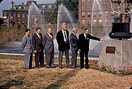
People celebrating the opening of Holyoke Water Power Park in 1960.
-
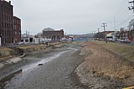
The Third Level Canal, emptied for cleaning in March 2018.
-
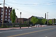
The Holyoke Canal Walk in May 2018.


Images for kids
-
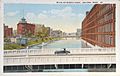
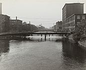
Bridges over the Middle Canal in Holyoke, around 1929.
.jpg)
