Horse Mesa Dam facts for kids
Quick facts for kids Horse Mesa Dam |
|
|---|---|
 |
|
| Country | United States |
| Location | Tonto National Forest, Maricopa County, Arizona |
| Coordinates | 33°35′27″N 111°20′38″W / 33.59083°N 111.34389°W |
| Construction began | 1924 |
| Opening date | 1927 |
| Owner(s) | U.S. Bureau of Reclamation |
| Dam and spillways | |
| Type of dam | Concrete thin arch |
| Impounds | Salt River |
| Height | 305 ft (93 m) |
| Length | 660 ft (200 m) |
| Width (crest) | 8 ft (2.4 m) |
| Width (base) | 57 ft (17 m) |
| Dam volume | 162,000 cu yd (124,000 m3) |
| Spillways | Gated concrete tunnel and over-the-crest |
| Spillway capacity | 150,000 cu ft/s (4,200 m3/s) |
| Reservoir | |
| Creates | Apache Lake |
| Total capacity | 245,138 acre⋅ft (0.302373 km3) |
| Catchment area | 5,842 sq mi (15,130 km2) |
| Surface area | 2,656 acres (1,075 ha) |
| Normal elevation | 1,919 ft (585 m) |
| Power station | |
| Turbines | 3x 112/3MW units, 1x 97MW pumped-storage unit |
| Installed capacity | 129 MW |
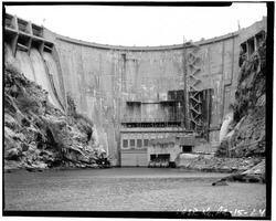
The Horse Mesa Dam is a large concrete dam located in the Superstition Mountains of Arizona. It sits northeast of Phoenix in Maricopa County. This dam helps control the Salt River.
This impressive structure is about 660 feet (200 m) long and 300 feet (91 m) high. It was built a long time ago, between 1924 and 1927. The dam is designed as a "thin arch," which means it curves to hold back the water.
One of the main jobs of the Horse Mesa Dam is to create electricity. It has special machines called hydroelectric generators. These use the force of moving water to make power. The dam can produce a total of 129 megawatts (MW) of electricity.
The dam and its related buildings were recognized as important in 2017. They were added to the National Register of Historic Places. This means they are protected for their historical value. The dam's name comes from a time when sheep herders let their horses graze on the nearby mesa.
What is a Dam?
A dam is a barrier that stops or restricts the flow of water. Dams create a reservoir (a lake) where water is stored. This stored water can be used for many things. These include drinking water, irrigation for farms, and making electricity.
Dams also help control floods. They can release water slowly to prevent rivers from overflowing. The Horse Mesa Dam is a great example of how dams serve multiple purposes.
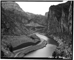
Apache Lake: The Reservoir
The Horse Mesa Dam creates a large lake called Apache Lake. This lake is formed by the dam holding back the Salt River. Apache Lake is a popular spot for fishing and boating.
The dam and Apache Lake are part of a series of dams on the Salt River. Horse Mesa Dam is located downstream from the Theodore Roosevelt Dam. It is also upstream from the Mormon Flat Dam. These dams work together to manage water resources in the area.