
Superstition Mountains facts for kids
Quick facts for kids Superstition Wilderness |
|
|---|---|
| Wi:kchsawa | |
|
IUCN Category Ib (Wilderness Area)
|
|

Praying Hands Formation
|
|
| Location | Maricopa / Pinal / Gila counties, Arizona, USA |
| Nearest city | Apache Junction, Arizona |
| Area | 159,757 acres (64,651 ha) |
| Established | 1939 |
| Governing body | United States Forest Service |
The Superstition Mountains (also called Wi:kchsawa in the Yavapai language) are a mountain range in Arizona. They are located just east of the big city area of Phoenix, Arizona. The most famous part is Superstition Mountain itself. This area is a popular spot for people from Phoenix to visit and enjoy nature.

Contents
What are the Superstition Mountains?
The Superstition Mountains are a group of mountains. They were once known in Spanish as Sierra de la Espuma, which means "Foam Mountains." This name might have come from how they look at certain times.
Where are the Superstition Mountains located?
These mountains are surrounded by major roads. U.S. Route 60 runs along their south side. Arizona State Route 88 is to the northwest. Arizona State Route 188 is to the northeast. This makes them fairly easy to access.
What is the Superstition Wilderness Area?
Most of the mountain range is part of the Superstition Wilderness Area. This is a special protected area managed by the government. It includes many natural features. One famous landmark is Weavers Needle. This tall, eroded rock formation is popular for rock climbing. It also plays a big part in the legend of the Lost Dutchman's Gold Mine.
Exploring the Superstition Mountains

Like most areas around Phoenix, the Superstition Mountains have a desert climate. This means summers are very hot. There are only a few places where water flows all year. The eastern part of the wilderness is higher up. This makes temperatures a bit cooler there.
Hiking and Trails
Many hiking trails wind through the mountains. You can start from different places. The Peralta Trailhead is the most popular starting point. Lost Dutchman State Park, on the west side of Superstition Mountain, also has several short walking trails.
Peralta Canyon is on the northeast side of Superstition Mountain. It has a popular trail that goes up to Fremont Saddle. From there, you get an amazing view of Weavers Needle. Miner's Needle is another well-known rock formation. It is also a favorite spot for hikers.
Ancient Sites
The area also contains Circlestone. This site includes ancient stone monuments. These structures tell us about people who lived here long ago.
How tall are the Superstition Mountains?
The highest point in the Superstition Mountains is Mound Mountain. It is located in the far eastern part of the range. Mound Mountain reaches an elevation of 6,266 ft (1,910 m). This makes it quite a tall peak in the desert landscape.
Legends of the Superstition Mountains

The Superstition Mountains are famous for their many legends. The most well-known is the story of the Lost Dutchman's Gold Mine.
The Lost Dutchman's Gold Mine
The legend says that a German immigrant named Jacob Waltz found a huge amount of gold in the Superstition Wilderness. Before he died in Phoenix in 1891, he supposedly told Julia Thomas where it was. She was a boarding-house owner who had cared for him. Many people have claimed to find Waltz's mine, but none of these claims have ever been proven true.
You can learn more about these legends at the Superstition Mountain Museum. It is located on the Apache Trail. The museum displays items related to the Lost Dutchman story.
Apache Beliefs
Some Apache people have their own beliefs about the Superstition Mountains. They believe that a hole leading to the lower world, or "hell," is located there. They say that strong winds blowing from this hole cause the dust storms in the Phoenix area.
Nearby Communities
Several towns and cities are close to the Superstition Mountains:
- Apache Junction, Arizona
- Gold Canyon, Arizona
- Mesa, Arizona
- Superior, Arizona
- Tortilla Flat, Arizona
Images for kids
-
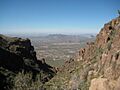
View from the Flatiron hiking trail in February 2008.

See also
 In Spanish: Montañas de la Superstición para niños
