
Apache Junction, Arizona facts for kids
Quick facts for kids
Apache Junction, Arizona
|
|||||
|---|---|---|---|---|---|

Welcome marker
|
|||||
|
|||||
| Motto(s):
"Surrounded by Legends"
|
|||||

Location in Pinal and Maricopa counties, Arizona
|
|||||

Apache Junction, Arizona
Location in Arizona

Apache Junction, Arizona
Location in the United States
|
|||||
| Country | United States | ||||
| State | Arizona | ||||
| Counties | |||||
| Incorporated | November 24, 1978 | ||||
| Government | |||||
| • Type | Council–manager | ||||
| Area | |||||
| • Total | 35.08 sq mi (90.86 km2) | ||||
| • Land | 35.07 sq mi (90.83 km2) | ||||
| • Water | 0.01 sq mi (0.03 km2) | ||||
| Elevation | 1,700 ft (500 m) | ||||
| Population
(2020)
|
|||||
| • Total | 38,499 | ||||
| • Density | 1,097.81/sq mi (423.86/km2) | ||||
| Time zone | UTC-7 (MST (no daylight saving time)) | ||||
| ZIP codes |
85119–85120
|
||||
| Area code(s) | 480 | ||||
| FIPS code | 04-02830 | ||||
| GNIS feature ID | 2409718 | ||||


Apache Junction (which is Hagosgeed in Western Apache) is a city in Arizona, United States. It is mostly located in Pinal County, with a small part in Maricopa County, Arizona. In 2020, about 38,499 people lived there.
The city got its name because it is where the Apache Trail and the Old West Highway meet. The area was once called Youngberg. To the east of Apache Junction, you can see Superstition Mountains, which is a famous mountain range.
Contents
History of Apache Junction
The area where Apache Junction is located has a rich history. It became an important landmark. In 1922, a beautiful scenic road called the Apache Trail was opened to the public. This road is now part of a 120-mile (193 km) long "circle trail" that starts and ends in Apache Junction.
Native American groups like the O'odham Jeweḍ, Akimel O'odham (also known as Upper Pima), and Hohokam people have strong historical ties to this land.
Exploring Apache Junction's Geography
Apache Junction is in the northern part of Pinal County. A small section of the city reaches west into Maricopa County. The city borders Mesa to the west and Gold Canyon to the southeast.
Downtown Phoenix is about 33 miles (53 km) to the west. You can get there using U.S. Route 60. This highway also goes east for about 54 miles (87 km) to Globe. Another road, Arizona State Route 88, follows the old Apache Trail. It goes northeast from Apache Junction through the Superstition Mountains. This route leads to Theodore Roosevelt Lake.
Apache Junction is part of the larger Phoenix-Mesa-Chandler Metropolitan Area. The city covers about 35.1 square miles (90.9 km²). Only a tiny part of this area is water.
Mountains and Natural Areas
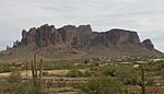
The city is surrounded by amazing natural features. To the east, you'll find the Superstition Mountains. This area is a federal wilderness area, which means it's protected and kept wild. It's also famous for the legend of the Lost Dutchman's Gold Mine.
To the north are the Goldfield Mountains and the Bulldog Recreation Area. Near the Superstition Mountain, you can visit Goldfield Ghost Town. This is a tourist spot that looks like an old mining town. It's located just off Highway 88, also known as the Apache Trail.
In October 2021, Apache Junction grew bigger. It added ten square miles (26 km²) to its southern boundary.
Climate in Apache Junction
Apache Junction has a hot semi-arid climate. This means it's generally hot and dry. The hottest temperature ever recorded in Apache Junction was 119°F (48°C). This happened on June 26, 1990, and again on July 27–28, 1995. The coldest temperature recorded was 17°F (-8°C) on January 14, 2007.
Population and People
| Historical population | |||
|---|---|---|---|
| Census | Pop. | %± | |
| 1970 | 2,390 | — | |
| 1980 | 9,935 | 315.7% | |
| 1990 | 18,100 | 82.2% | |
| 2000 | 31,814 | 75.8% | |
| 2010 | 35,840 | 12.7% | |
| 2020 | 38,499 | 7.4% | |
| 2022 (est.) | 40,173 | 12.1% | |
| U.S. Decennial Census | |||
Apache Junction first appeared in the U.S. Census in 1970 as a small village. It officially became a city in 1978.
According to the 2010 census, there were 35,840 people living in the city. There were about 15,574 households. Many people lived in families, with 44.6% being married couples. About 19.6% of households had children under 18 living with them.
The average age of people in Apache Junction was 47.5 years. About 19.9% of the population was under 20 years old.
Historic Structures and Museums
Apache Junction has some cool historic buildings and places to visit.
The Superstition Mountain Museum has many interesting exhibits. You can see movie sets and other items from Apacheland. Apacheland was a large movie ranch that opened in 1960. Sadly, a fire in 1969 destroyed parts of it. The museum saved some of these items.
You can also visit the ghost town of Goldfield. Goldfield was a mining town that started in 1893. It was right next to Superstition Mountain. When the mine stopped producing enough gold, the town became empty. Today, Goldfield and its old buildings have been brought back to life as a fun tourist attraction.
-
The Lost Dutchman Mine, located in the Superstition Mountains
-

The Audie Murphy Barn on the grounds of Superstition Mountain Museum, moved there from the Apacheland Movie Ranch
-
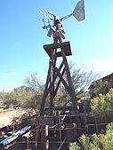
A 19th-century windmill located on the grounds of Superstition Mountain Museum


Getting Around Apache Junction
U.S. Route 60 runs through Apache Junction, making it easy to travel by car.
While there are no local city buses, Greyhound Lines offers bus service. You can catch a bus from Apache Junction to Phoenix or El Paso, with a stop in Globe.
Education in Apache Junction
Students in Apache Junction attend schools within the Apache Junction Unified School District.
See also
 In Spanish: Apache Junction para niños
