
Tortilla Flat, Arizona facts for kids
Quick facts for kids
Tortilla Flat, Arizona
|
|
|---|---|

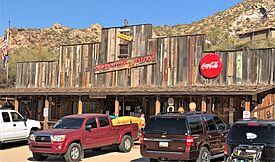
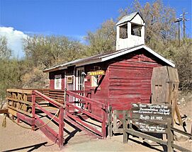
The Country Store and the Superstition Saloon (2021)
|
|

Location in Maricopa County and the state of Arizona
|
|
| Country | United States |
| State | Arizona |
| County | Maricopa |
| Elevation | 1,750 ft (530 m) |
| Population
(2020)
|
|
| • Total | 6 |
| Time zone | UTC-7 (Mountain (MST)) |
| ZIP codes |
85190
|
Tortilla Flat is a tiny community in Arizona, United States. It's in Maricopa County, northeast of Apache Junction. This special place is the very last stagecoach stop still around on the famous Apache Trail.
It's thought to be Arizona's smallest official "community" with its own U.S. Post Office. Only 6 people live there! You can visit Tortilla Flat by driving on the Apache Trail (State Route 88).
Tortilla Flat started as a camping spot for people looking for gold. These "prospectors" searched in the Superstition Mountains in the late 1800s. Later, it became a camp for workers building the Theodore Roosevelt Dam. Since 1904, Tortilla Flat has always had people living there, though usually fewer than 100.
A big flood in 1942 caused a lot of damage. Many people moved away after that. Today, the town has a country store, a saloon (which is a bar and restaurant), and a BBQ patio. There's also a gift shop and a small museum. Most of these buildings were built in the late 1980s after a fire. The gift shop was added in 2009.
Many hiking trails into the Superstition Mountains start close to Tortilla Flat.
Contents
The Story of Tortilla Flat
Early Days and Gold Seekers
Long ago, a creek flowed through the valley where Tortilla Flat is now. The Yavapai people used this area to travel through the Superstition Mountains. This path became known as the "Yavapai Trail."
In the 1500s, Spanish explorers came looking for gold. They were searching for the "Seven Cities of Gold." Later, in the 1800s, people like Don Miguel Peralta from Mexico also looked for gold here. He reportedly found a lot of gold in 1847 and 1848.
As more settlers arrived, military outposts were needed. These protected people from Native Americans, whose land was being taken. Even though the journey was hard, the Yavapai Trail was an important route. It led into the Tonto Basin. Tortilla Flat was likely a camping spot because it had water and food for animals. However, it wasn't a permanent town back then.
A Stop for Stagecoaches
Tortilla Flat really began to grow in 1904. This was when a road was being built to the Roosevelt Dam. The area became a stagecoach stop for people carrying supplies to the dam.
After the road was finished, Roosevelt Dam became a popular place for tourists. Tortilla Flat then served as a stop for tourists and mail carriers. This continued through the 1930s.
How Tortilla Flat Got Its Name
One story says Tortilla Flat got its name from a nearby mountain. This mountain looked like a tortilla, a flat, round bread.
Another story comes from John Cline, an early settler in the Tonto Basin. He said that around 1867, he was stuck in this spot for several days. All he had to eat was flour, so he made tortillas.
Protecting the Land
The Forest Service created the Tonto National Forest in 1905. This was important for the Salt River Project. This project was building dams and needed to protect the Salt River watershed. Cattle grazing had removed too much plant life.
The freight camps, like the one at Tortilla Flat, were on Forest Service land. People who wanted to live in Tortilla Flat permanently continued to lease the land over the years.
Gallery
-
The Superstition Saloon
-
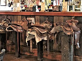
The bar in the Saloon has stools with saddles on them
-
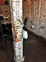
The walls of the Saloon are papered with dollar bills
-
The Mercantile/Gift Shop with some of the rock formations of the area in the background
-
The town's Museum is a replica schoolhouse on the site where the first school opened in 1932
-
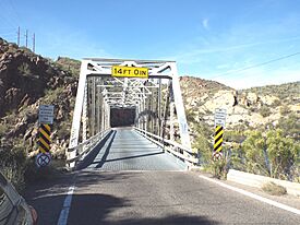
Mormon Flat Bridge, built in 1924 and located on the Apache Trail (State Route 88) over Willow Creek, 3.8 miles west of Tortilla Flat, was listed in the National Register of Historic Places (NRHP) on September 30, 1988 (#88001598).
-
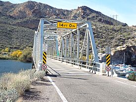
Boulder Creek Bridge, built in 1937 and located on the Apache Trail over Boulder Creek, 1 mile west of Tortilla Flat, was listed in the NRHP on March 31, 1989 (#8800159).


