
Superior, Arizona facts for kids
Quick facts for kids
Superior
|
||
|---|---|---|
| Superior, Arizona | ||

Superior from the air, looking north (2010)
|
||
|
||

Location of Superior in Pinal County, Arizona.
|
||

Superior
Location in the United States
|
||
| Country | United States | |
| State | Arizona | |
| County | Pinal | |
| Incorporated | 1976 | |
| Area | ||
| • Total | 1.96 sq mi (5.08 km2) | |
| • Land | 1.96 sq mi (5.08 km2) | |
| • Water | 0.00 sq mi (0.00 km2) | |
| Elevation | 2,888 ft (880 m) | |
| Population
(2020)
|
||
| • Total | 2,407 | |
| • Density | 1,226.18/sq mi (473.48/km2) | |
| Time zone | UTC-7 (MST (no DST)) | |
| ZIP code |
85173
|
|
| Area code(s) | 520 | |
| FIPS code | 04-71300 | |
| GNIS feature ID | 34981 | |

Superior (called Yooʼ Łigai in the Western Apache language) is a town in Pinal County, Arizona, United States. It's the oldest town in northern Pinal County. In 2020, about 2,407 people lived there. Superior started as a town built around mining. First, people mined silver, and later they mined copper. Today, people are looking into mining a very large copper deposit called Resolution Copper.
Contents
History of Superior
Superior has a rich history, especially tied to the land and mining.
Early Days and Apache Land
Superior, along with nearby towns like Globe and Ray, was once part of a huge Apache reservation. But when silver and copper were found there, these areas were taken from the reservation. They became public land, open for mining.
The Legend of Apache Leap
In 1872, during the American Indian Wars, a group of Apache horsemen were surprised by the United States Cavalry. This happened near Picket Post Mountain. After losing many men, the Apache went up a mountain. This mountain was later named "Apache Leap." Local stories say that the remaining Apache warriors chose to jump off the cliff rather than be captured. This is how the mountain got its name.

How Superior Got Its Name
Superior was first called Queen, then Hastings. In 1900, the town was officially mapped out under the name Hastings. The Queen area had about 100 people around 1880. It had a general store, two hotels, many saloons, and a post office. The Queen post office closed in 1881.
The town of Superior was planned in 1902. It was named after the Lake Superior and Arizona Copper Company (LS&A). The Superior post office opened on December 29, 1902.
Schools in the Past
Before 1950, schools in Superior separated students. White students and Mexican students went to different schools. This changed after a big court decision in the United States called Brown v. Board of Education.
Mining in Superior
Mining has always been a big part of Superior's story.
The Silver King and Magma Mines
The Silver King Mine started on March 22, 1875. Charles G. Mason and four friends found native silver there. They claimed the Silver King area. A week later, on March 29, 1875, the Silver Queen (Magma) vein was found. The Silver Queen Mining Company was started in 1880.
However, when the silver ran out, the Silver Queen mine closed in 1893. The Silver King mine closed in 1896.
The Magma Copper Company
In 1910, William Boyce Thompson and George Gunn bought the Silver Queen Mine. They started the Magma Copper Company. In 1914, they built a plant that could process 300 tons of ore each day.
A narrow-gauge railway was built in 1915. It connected Superior to the Southern Pacific Railroad. This railway was made wider in 1923 to fit standard trains. A smelter (a place to melt ore) was built in 1924.
Magma Mine Closes and Reopens
After 71 years of work, the Magma Mine closed in August 1982. This happened because it cost too much to run, and copper prices were low. The mine reopened in September 1990 but closed again on June 28, 1996.
During its 86 years of operation (1910–1996), the Magma Mine produced a lot of metal. It recovered about 1.3 million tons of copper. It also produced 36,550 tons of zinc, 686,000 ounces of gold, and 34.3 million ounces of silver.
Today, the old Magma No. 9 shaft on Apache Leap is being used. It helps explore the huge Resolution Copper deposit located deep below.
Geography of Superior
Superior is located about 70 miles (113 km) east of Phoenix. It's also about the same distance north of Tucson. The town covers a total area of 1.96 square miles (5.08 km2). All of this area is land.
Population and People
| Historical population | |||
|---|---|---|---|
| Census | Pop. | %± | |
| 1920 | 2,464 | — | |
| 1930 | 4,295 | 74.3% | |
| 1960 | 4,875 | — | |
| 1970 | 4,975 | 2.1% | |
| 1980 | 4,600 | −7.5% | |
| 1990 | 3,468 | −24.6% | |
| 2000 | 3,254 | −6.2% | |
| 2010 | 2,837 | −12.8% | |
| 2020 | 2,407 | −15.2% | |
| U.S. Decennial Census | |||
In 2000, there were 3,254 people living in Superior. There were 1,237 homes, and 847 of these were families. The population density was about 1,685 people per square mile.
About 26.9% of homes had children under 18 living there. About 48.3% were married couples. The average home had 2.63 people, and the average family had 3.20 people.
The population was spread out by age. About 26.9% were under 18. About 19.9% were 65 or older. The average age was 39 years. For every 100 females, there were about 99 males.
The average income for a household in the town was $27,069. For families, it was $31,250. About 27.8% of the people lived below the poverty line. This included 39.0% of those under 18.
Places to Visit
Superior has interesting places to explore.
Boyce Thompson Arboretum
The Boyce Thompson Arboretum is a large botanical collection. It covers 323 acres (1.31 km2). It has many different types of habitats and a 1.5-mile (2.4 km) walking trail. Started in 1924, it is the largest and oldest botanical garden in Arizona.
Climate in Superior
Superior has a hot semi-arid climate. This means it's usually dry and warm.
Temperatures and Rain
In January, the average high temperature is 61 °F (16 °C). The low is 43 °F (6 °C). In July, the average high is 98 °F (37 °C). The low is 76 °F (24 °C).
Superior gets just over 18 inches of rain each year. Higher areas get more rain. Even with good rainfall, Superior is too low for much snow in winter.
| Climate data for Superior, Arizona | |||||||||||||
|---|---|---|---|---|---|---|---|---|---|---|---|---|---|
| Month | Jan | Feb | Mar | Apr | May | Jun | Jul | Aug | Sep | Oct | Nov | Dec | Year |
| Record high °F (°C) | 81 (27) |
87 (31) |
91 (33) |
96 (36) |
105 (41) |
111 (44) |
112 (44) |
110 (43) |
106 (41) |
102 (39) |
89 (32) |
83 (28) |
112 (44) |
| Mean daily maximum °F (°C) | 60.9 (16.1) |
64.1 (17.8) |
68.5 (20.3) |
76.4 (24.7) |
86.1 (30.1) |
95.6 (35.3) |
97.7 (36.5) |
95.4 (35.2) |
92.3 (33.5) |
82.5 (28.1) |
69.8 (21.0) |
61.6 (16.4) |
79.2 (26.2) |
| Mean daily minimum °F (°C) | 43.2 (6.2) |
45.4 (7.4) |
48.2 (9.0) |
54.4 (12.4) |
62.7 (17.1) |
72.0 (22.2) |
75.7 (24.3) |
74.2 (23.4) |
71.2 (21.8) |
62.0 (16.7) |
51.1 (10.6) |
44.0 (6.7) |
58.7 (14.8) |
| Record low °F (°C) | 20 (−7) |
20 (−7) |
24 (−4) |
29 (−2) |
38 (3) |
51 (11) |
59 (15) |
61 (16) |
50 (10) |
33 (1) |
29 (−2) |
19 (−7) |
19 (−7) |
| Average rainfall inches (mm) | 2.00 (51) |
1.98 (50) |
2.02 (51) |
.80 (20) |
.34 (8.6) |
.26 (6.6) |
1.91 (49) |
2.80 (71) |
1.48 (38) |
1.18 (30) |
1.41 (36) |
2.11 (54) |
18.29 (465.2) |
| Average rainy days (≥ 0.01 inch) | 5 | 5 | 5 | 3 | 2 | 1 | 7 | 8 | 4 | 3 | 4 | 5 | 52 |
| Source: Western Regional Climate Center | |||||||||||||
Transportation in Superior
Greyhound Lines offers bus service in Superior. It is part of their route that goes from Phoenix to El Paso, passing through Globe.
Education in Superior
Schools in Superior are part of the Superior Unified School District.
Images for kids
-
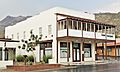
The renovated and restored Hotel Magma
-
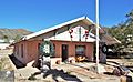
The Bob Jones House, home of Robert Taylor Jones, who became Arizona's sixth governor.
-
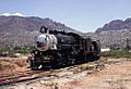
Magma Arizona Railroad in Superior (1967)
-
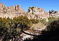
The riparian (river-associated) area of the Boyce Thompson Arboretum. The Boyce Thompson mansion can be seen at the right.
-
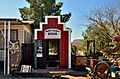
World's Smallest Museum
,_100_Main_Street_at_North_Magma,_Superior.jpg)


See also
 In Spanish: Superior (Arizona) para niños
