Houston, Pennsylvania facts for kids
Quick facts for kids
Houston
|
|
|---|---|
|
Borough
|
|

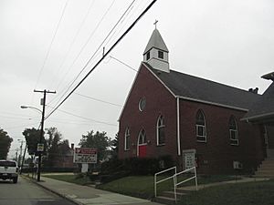
Pike Street north of downtown
|
|

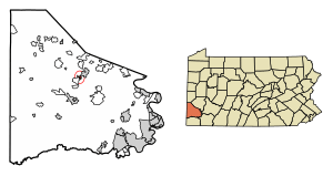
Location of Houston in Washington County, Pennsylvania.
|
|
| Country | United States |
| State | Pennsylvania |
| County | Washington |
| Established | 1901 |
| Area | |
| • Total | 0.41 sq mi (1.06 km2) |
| • Land | 0.41 sq mi (1.06 km2) |
| • Water | 0.00 sq mi (0.00 km2) |
| Population
(2020)
|
|
| • Total | 1,172 |
| • Density | 2,851.58/sq mi (1,101.31/km2) |
| Time zone | UTC-5 (EST) |
| • Summer (DST) | UTC-4 (EDT) |
| ZIP code |
15342
|
| Area code(s) | 724 |
Houston is a small town, also called a borough, located in Washington County, Pennsylvania, United States. In 2020, about 1,165 people lived there.
Students living in Houston and the nearby Chartiers Township go to school in the Chartiers-Houston School District.
Contents
Exploring Houston's Location and Waterways
Houston is found at these coordinates: 40°14′59″N 80°12′37″W / 40.24972°N 80.21028°W. It covers a total area of about 0.4 square miles (1.0 square kilometer), and all of it is land.
Several waterways flow through Houston, making its geography unique:
- Chartiers Creek runs through the borough.
- Chartiers Run joins Chartiers Creek right in Houston.
- Plum Run also meets Chartiers Run within the borough.
Neighboring Communities Around Houston
Houston shares its borders with a few other places.
- To the north, south, and west, it borders Chartiers Township.
- To the northeast, you'll find Canonsburg.
- To the east and southeast, Houston is next to North Strabane Township.
The Story of Houston: How the Town Began
The land where Houston stands today was bought on January 24, 1827, by Daniel Houston. He was a relative of General Sam Houston, a famous leader who helped Texas gain independence from Mexico.
Later, in 1871, a railroad called the Chartiers Valley Railroad was built through the area. Daniel's son, David C. Houston, realized this was a great spot for a town. He then planned out what would become Houstonville. The very first house in the new town was finished in the summer of 1871. A few years later, another area called Riggletown was added.
Finally, on May 13, 1901, Houston officially became a borough. It was formed from parts of Chartiers and North Strabane Townships.
Population Changes in Houston Over Time
| Historical population | |||
|---|---|---|---|
| Census | Pop. | %± | |
| 1910 | 793 | — | |
| 1920 | 1,398 | 76.3% | |
| 1930 | 1,742 | 24.6% | |
| 1940 | 1,610 | −7.6% | |
| 1950 | 1,957 | 21.6% | |
| 1960 | 1,865 | −4.7% | |
| 1970 | 1,812 | −2.8% | |
| 1980 | 1,568 | −13.5% | |
| 1990 | 1,445 | −7.8% | |
| 2000 | 1,314 | −9.1% | |
| 2010 | 1,296 | −1.4% | |
| 2020 | 1,165 | −10.1% | |
| Sources: | |||
In 2000, there were 1,314 people living in Houston. These people lived in 614 households, with 340 of them being families. The population density was about 3,582 people per square mile (1,383 people per square kilometer).
Most of the people in Houston were White (94.44%). There were also African American (3.65%), Native American (0.08%), and Asian (0.53%) residents. About 0.38% of the population was Hispanic or Latino.
The average household had 2.13 people, and the average family had 2.91 people. About 22.8% of households had children under 18. Also, 38.4% were married couples living together.
The age of people in Houston varied:
- 19.1% were under 18 years old.
- 7.8% were between 18 and 24.
- 28.5% were between 25 and 44.
- 23.3% were between 45 and 64.
- 21.3% were 65 years or older.
The average age in Houston was 42 years.
See also
 In Spanish: Houston (Pensilvania) para niños
 | Valerie Thomas |
 | Frederick McKinley Jones |
 | George Edward Alcorn Jr. |
 | Thomas Mensah |


