
Howellville, Texas facts for kids
Quick facts for kids
Howellville, Texas
|
|
|---|---|

Howellville, Texas
Location in Texas

Howellville, Texas
Location in the United States
|
|
| Country | United States |
| State | Texas |
| County | Harris |
| Elevation | 85 ft (26 m) |
| Time zone | UTC-6 (Central (CST)) |
| • Summer (DST) | UTC-5 (CDT) |
| ZIP code |
77082
|
| Area code(s) | 281 |
Howellville, also known as Howell, is a small community in Harris County, Texas, United States. It's not a city with its own government, but rather an unincorporated community that has become part of the larger Greater Houston area. You won't find road signs pointing to it, but it's located where Alief Clodine Road meets Sugar Land Howell Road on the west side of Houston. This area used to be a stop on an old railroad line that no longer exists.
Contents
Exploring Howellville's Location
Howellville is found on Alief Clodine Road. It is about 0.6 miles (1 km) east of Texas State Highway 6. The Westpark Tollway runs just north of Alief Clodine Road.
Important Places Nearby
- Schools: O'Donnell Middle School, part of the Alief Independent School District, is right at the corner of Alief Clodine Road and Sugar Land Howell Road. Hearne Elementary School is also very close, just one block south.
- Homes and Businesses: The Park Village Apartments are on the southwest side of the main intersection. You can also find a few manufacturing businesses a short distance away.
- Natural Features: An artificial lake, which is part of Brays Bayou, is about 400 yards (366 meters) to the north.
- Roads: The name "Howell" is still used in two local roads. Sugar Land Howell Road starts here and goes south for about 2.8 miles (4.5 km). State Highway 6 is also called Addicks Howell Road in this area.
The Story of Howellville
Howellville began as a small town founded by T. E. Howell. It was located about 10 miles (16 km) southwest of Houston.
How Howellville Started
- Railroad Stop: The community became a stop on the San Antonio and Aransas Pass Railway. A map from 1919 shows the site named "Howell" on this railroad line.
- Post Office: Howellville even had its own post office from 1920 to 1934.
- Farming Life: With the help of a drainage program, the land around Howellville was good for dairy farming. Farmers also grew crops like corn and rice.
- Population: From the 1920s to the 1990s, about 36 people lived in the Howellville area.
Changes Over Time
- New Names and Railroads: A 1955 map called the community "Howellville" and showed it on the Texas and New Orleans Railroad. By 1982, another map identified it on the Southern Pacific Railroad.
- Modern Development: The land where the Southern Pacific Railroad used to be was sold to the Harris County Toll Road Authority. This is where the Westpark Tollway was built.
Gallery
-
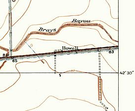
Howell is on a 1915 USGS map. The railroad is identified as the San Antonio and Aransas Pass while the road going north from the 85' benchmark (BM) is Addicks Road.
-
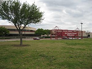
Ann Osterloh O'Donnell Middle School is at Alief-Clodine Road and Howell Sugar Land Road. The school is part of Alief Independent School District.
-
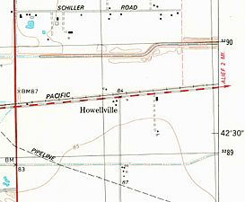
Howellville appears on a 1982 USGS map. State Highway 6 is the vertical red line at left while Alief-Clodine Road is the dashed red and white line from left to right.


