Huancabamba facts for kids
Quick facts for kids
Huancabamba
|
|
|---|---|
|
Village
|
|
| Country | |
| Region | Piura |
| Province | Huancabamba |
| District | Huancabamba |
| Elevation | 1,929 m (6,329 ft) |
| Time zone | UTC-5 (PET) |
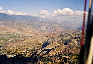
Huancabamba is a charming town located in the northern part of Peru. It serves as the capital of the Huancabamba Province within the Piura Region. This town is nestled in a beautiful valley, right alongside the Huancabamba River.
Long ago, an important Inca road used to pass through this very valley. This ancient path connected major cities like Quito and Cajamarca. Imagine ancient travelers walking through here!
Contents
Understanding Huancabamba's Climate
Huancabamba has a unique climate because of its location high in the mountains. It's not too hot and not too cold, making it a comfortable place to live. The town experiences different amounts of rain throughout the year.
| Climate data for Huancabamba, elevation 1,959 m (6,427 ft), (1991–2020) | |||||||||||||
|---|---|---|---|---|---|---|---|---|---|---|---|---|---|
| Month | Jan | Feb | Mar | Apr | May | Jun | Jul | Aug | Sep | Oct | Nov | Dec | Year |
| Mean daily maximum °C (°F) | 24.4 (75.9) |
24.0 (75.2) |
24.2 (75.6) |
24.4 (75.9) |
24.2 (75.6) |
23.6 (74.5) |
23.5 (74.3) |
23.9 (75.0) |
24.6 (76.3) |
25.4 (77.7) |
26.1 (79.0) |
24.9 (76.8) |
24.4 (76.0) |
| Mean daily minimum °C (°F) | 13.4 (56.1) |
13.9 (57.0) |
14.1 (57.4) |
13.9 (57.0) |
13.1 (55.6) |
12.9 (55.2) |
12.7 (54.9) |
12.8 (55.0) |
13.3 (55.9) |
13.2 (55.8) |
12.6 (54.7) |
13.4 (56.1) |
13.3 (55.9) |
| Average precipitation mm (inches) | 56.3 (2.22) |
71.3 (2.81) |
88.0 (3.46) |
63.6 (2.50) |
33.8 (1.33) |
14.9 (0.59) |
11.2 (0.44) |
6.9 (0.27) |
13.4 (0.53) |
44.2 (1.74) |
53.1 (2.09) |
55.0 (2.17) |
511.7 (20.15) |
| Source: National Meteorology and Hydrology Service of Peru | |||||||||||||
Temperature and Rainfall Patterns
Looking at the weather data, you can see that the highest temperatures are usually around 24 to 26 degrees Celsius (about 75 to 79 degrees Fahrenheit). The lowest temperatures are around 12 to 14 degrees Celsius (about 54 to 57 degrees Fahrenheit). This means the weather is generally mild all year round.
The rainiest months are typically from January to April, with March often being the wettest. The driest months are usually from July to September. This pattern of wet and dry seasons is common in many parts of Peru.
Government and Leadership
Like any town, Huancabamba has leaders who help run things. The main leader of the town is called the Mayor. The current Mayor is Valentin Quevedo Peralta. The Mayor and other local officials work to make decisions for the community. They help manage services like roads, public spaces, and other important things that keep the town running smoothly for its residents.
Exploring the Huancabamba Valley
The valley where Huancabamba is located is known for its natural beauty. The Huancabamba River flows through it, providing water and supporting the local environment. This area is part of the larger Piura Region, which is known for its diverse landscapes, from coastal areas to high mountains. The valley's history is deeply connected to the ancient Inca civilization, as it was a key route for their vast road network.
See also
 In Spanish: Huancabamba para niños
 | Valerie Thomas |
 | Frederick McKinley Jones |
 | George Edward Alcorn Jr. |
 | Thomas Mensah |


