Hulett, Wyoming facts for kids
Quick facts for kids
Hulett, Wyoming
|
|
|---|---|

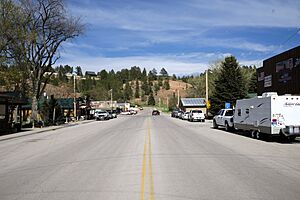
Main Street (WY Hwy 24) in Hulett
|
|

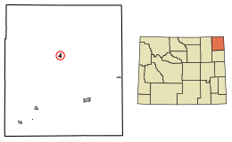
Location of Hulett in Crook County, Wyoming.
|
|
| Country | United States |
| State | Wyoming |
| County | Crook |
| Area | |
| • Total | 0.86 sq mi (2.23 km2) |
| • Land | 0.86 sq mi (2.23 km2) |
| • Water | 0.00 sq mi (0.00 km2) |
| Elevation | 3,747 ft (1,142 m) |
| Population
(2020)
|
|
| • Total | 309 |
| • Estimate
(2019)
|
427 |
| • Density | 494.79/sq mi (191.12/km2) |
| Time zone | UTC−7 (Mountain (MST)) |
| • Summer (DST) | UTC−6 (MDT) |
| ZIP code |
82720
|
| Area code(s) | 307 |
| FIPS code | 56-39105 |
| GNIS feature ID | 1589796 |
Hulett is a small town in Crook County, Wyoming, in the United States. It is a quiet place with a population of 309 people, according to the 2020 census. Hulett is known for being very close to Devils Tower, a famous national monument.
Contents
Exploring Hulett's Location
Hulett is located in the northeastern part of Wyoming. It covers a total area of about 0.87 square miles (2.23 square kilometers). All of this area is land. The Belle Fourche River flows right through the town, adding to its natural beauty.
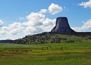
One of the most exciting things about Hulett's location is its closeness to Devils Tower. This amazing rock formation is only about 9 miles (14 kilometers) away. Devils Tower was the very first place in the United States to be named a national monument.
Hulett's Weather and Climate
Hulett experiences a climate with warm summers and cold winters. In summer, temperatures can get quite hot, sometimes reaching over 100 degrees Fahrenheit (38 degrees Celsius). Winters are very cold, with temperatures often dropping below freezing. It can even get as low as -44 degrees Fahrenheit (-42 degrees Celsius) in January!
The town gets a moderate amount of rain and snow throughout the year. Spring and early summer usually see the most rainfall. Snowfall is common in the winter months, making the landscape beautiful and white.
Who Lives in Hulett?
In 2010, there were 383 people living in Hulett, making up 164 households. By 2020, the population was 309 people. Most people in Hulett are White, and a small number are Native American or from two or more races. A small percentage of the population is Hispanic or Latino.
Many households in Hulett have children under 18 living with them. The town has a mix of married couples, single-parent families, and individuals living alone. The average age of people in Hulett is around 39.8 years old.
Learning and Education in Hulett
Students in Hulett attend public schools managed by Crook County School District #1. The main school is Hulett School, which teaches students from kindergarten all the way through 12th grade. This means younger kids and teenagers go to the same campus.
Hulett also has its own public library. It is a part of the Crook County Public Library System. The library is a great place for everyone in town to read, learn, and find information.
Getting Around Hulett
Hulett has its own airport, called Hulett Municipal Airport. The town of Hulett owns and operates this airport. It helps people travel to and from the area, especially for those visiting Devils Tower or other nearby attractions.
Images for kids
-
Devils Tower is a famous landmark near Hulett.
See also
 In Spanish: Hulett (Wyoming) para niños
 | Mary Eliza Mahoney |
 | Susie King Taylor |
 | Ida Gray |
 | Eliza Ann Grier |


