Hunterstown, Pennsylvania facts for kids
Quick facts for kids
Hunterstown, Pennsylvania
|
|
|---|---|

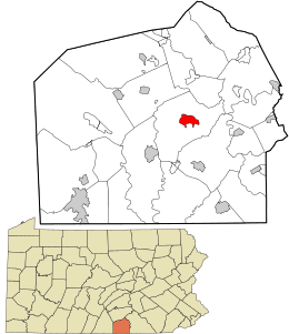
Location in Adams County and the state of Pennsylvania.
|
|
| Country | United States |
| State | Pennsylvania |
| County | Adams |
| Township | Straban |
| Area | |
| • Total | 1.73 sq mi (4.48 km2) |
| • Land | 1.72 sq mi (4.47 km2) |
| • Water | 0.01 sq mi (0.01 km2) |
| Elevation | 554 ft (169 m) |
| Population
(2020)
|
|
| • Total | 506 |
| • Density | 293.50/sq mi (113.31/km2) |
| Time zone | UTC-5 (Eastern (EST)) |
| • Summer (DST) | UTC-4 (EDT) |
| Area code(s) | 717 |
| GNIS feature ID | 1177622 |
| FIPS code | 42-36352 |
Hunterstown is a small community located in Straban Township, Adams County, Pennsylvania, United States. It is known as a census-designated place, which means it's an area that the government counts as a separate community for population statistics. In 2020, about 506 people lived here.
Hunterstown is situated along Pennsylvania Route 394, also called Shrivers Corner Road. It is about 5 miles (8 km) northeast of Gettysburg, a very famous historical town.
This community is home to some important historical sites. The Hunterstown Historic District and the Great Conewago Presbyterian Church are both listed on the National Register of Historic Places. This means they are recognized for their special historical value.
Hunterstown's History
Hunterstown played a small but important role during the American Civil War. In 1863, a major battle called the Battle of Gettysburg took place nearby.
The Battle of Hunterstown
Just before the main Battle of Gettysburg, there was a brief fight in Hunterstown. This happened on July 2, 1863. It was a cavalry skirmish, which means it was a small fight between soldiers on horseback. This event is now known as the Battle of Hunterstown. It was one of the many smaller clashes that happened around Gettysburg during that time.
See also
 In Spanish: Hunterstown para niños
 | Aurelia Browder |
 | Nannie Helen Burroughs |
 | Michelle Alexander |

