Hyndburn Brook facts for kids
Quick facts for kids Hyndburn Brook |
|
|---|---|

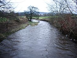
Hyndburn Brook, from the Mill Lane Bridge. (January 2008)
|
|
| Country | England |
| Physical characteristics | |
| Main source | West of Church, Lancashire. |
| River mouth | River Calder, south of Martholme. |
| Length | 4.5 mi (7.3 km) |
Hyndburn Brook is a small river in eastern Lancashire, England. It is about 7.3 kilometers (4.5 miles) long. This brook is an important part of the local water system. It eventually joins a bigger river called the River Calder.
Contents
Where Hyndburn Brook Begins
Hyndburn Brook is thought to start where two smaller streams meet. These streams are called Tinker Brook and White Ash Brook. This meeting point is west of a town called Church. From there, the river flows north.
As it travels, Hyndburn Brook collects water from other streams. It meets the River Hyndburn just before the M65 Motorway bridge. It also picks up Bottom Syke, which comes from Dunkenhalgh. Further along, it is joined by Shaw Brook and Spaw Brook, east of Rishton.
The Brook's Journey
The brook then turns towards the northeast. Between Great Harwood and the Oakenshaw side of Clayton-le-Moors, it is joined by Norden Brook. After that, Harwood Brook adds its water.
Hyndburn Brook flows under the A680 Hyndburn Bridge. Finally, it joins the River Calder. This happens near the area's waste water treatment works, at Martholme.
The Start of Tinker Brook and White Ash Brook
Both Tinker Brook and White Ash Brook help drain the northern part of Oswaldwistle Moor. Tinker Brook actually starts as Jackhouse Brook. It forms where Cocker Brook and Cocker Lumb meet near Jackhouse. Cocker Brook flows through old reservoirs called Warmwithens and Jackhouse. It becomes Tinker Brook when it enters the southern part of Oswaldtwistle. Here, it also collects Whams Brook.
White Ash Brook begins as Lottice Brook, northeast of Belthorn. It flows north until it turns east near the Haslingden Old Road bridge. It changes its name to White Ash Brook when it flows under Smithes Bridge in Western Oswaldwistle.
What's in the Name?
The name Hyndburn might come from old English words. Hind (hind) meant a female deer. Burna (burna) meant a stream. So, it could mean "deer stream." The word "brook" (from old English broc) is a common name for a small stream. You often find this word used for streams in Southern and Central England.
Helping Fish Travel
There's an important project to help fish in the Hyndburn Brook. This project aims to allow migrating fish like salmon, trout, and eels to travel further upstream. In 2017, a special path for fish was built. This "fish bypass" was made at the Oakenshaw Print Works Weir. This weir was 4 meters (13 feet) high and built in the 1800s. The fish bypass officially opened in October 2017.
Another similar project started in June 2019. This one is further upstream at the Dunkenhalgh Weir, near Rishton. These projects help fish move freely along the river.
Rivers and Streams Joining Hyndburn Brook
Many smaller streams and brooks flow into Hyndburn Brook. These are called its tributaries. They add water to the main brook as it flows along.
Here are some of the streams that join Hyndburn Brook:
- Harwood Brook
- Causeway Brook
- Norden Brook
- Spaw Brook
- Shaw Brook
- Bottom Syke
- River Hyndburn
- White Ash Brook
- Wolfenden Syke
- Lottice Brook
- Tinker Brook
- Whams Brook
- Jackhouse Brook
- Cocker Brook
- White Syke
- Cocker Lumb
- Cocker Brook
 | Aurelia Browder |
 | Nannie Helen Burroughs |
 | Michelle Alexander |

