Hysham, Montana facts for kids
Quick facts for kids
Hysham, Montana
|
|
|---|---|

Location of Hysham, Montana
|
|
| Country | United States |
| State | Montana |
| County | Treasure |
| Area | |
| • Total | 0.22 sq mi (0.57 km2) |
| • Land | 0.22 sq mi (0.57 km2) |
| • Water | 0.00 sq mi (0.00 km2) |
| Elevation | 2,661 ft (811 m) |
| Population
(2020)
|
|
| • Total | 276 |
| • Density | 1,260.27/sq mi (486.98/km2) |
| Time zone | UTC-7 (Mountain (MST)) |
| • Summer (DST) | UTC-6 (MDT) |
| ZIP codes |
59038, 59076
|
| Area code(s) | 406 |
| FIPS code | 30-38350 |
| GNIS feature ID | 0772654 |
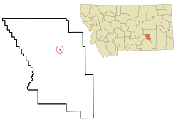
Hysham is a small town in Montana, United States. It is the main town, or county seat, of Treasure County. In 2020, about 276 people lived there.
Contents
Geography of Hysham
Hysham is located at 46.290535 degrees North and 107.229929 degrees West. This means it's in the northern part of the world, west of the Prime Meridian. The town covers about 0.57 square kilometers (0.22 square miles) of land.
The Yellowstone River flows along the northern edge of Hysham. The area around the town has rolling hills and lots of farmland.
History of Hysham
Early Days and Homesteading
When Montana became a state in 1889, the land where Hysham now sits was just open prairie. It was part of a very large county called Custer County. This area was also near the Crow Indian Reservation.
In 1906, the government moved the Crow Indian Reservation boundary. This opened up the land for people to start farms and ranches. This is how small towns like Hysham began to grow.
Ranching and the Railroad
Hysham's story is closely tied to ranching and the railroad. A huge cattle ranch called the Flying E operated in the area. Charlie J. Hysham came from Iowa to manage this ranch.
The Flying E ranch needed a lot of supplies. So, the Northern Pacific Railway built a special track, called a siding, in 1907. This siding was used to unload goods that Charlie Hysham ordered. This railroad stop became the very beginning of the town of Hysham.
Building the Town
The first building in Hysham was a general store, built by James O. Lockard. It also served as the town's first post office, and Lockard was the first postmaster. His land later became known as the "Lockard Addition" to Hysham.
Hysham grew slowly, like many frontier towns. First, there was a need for a business or a transportation stop. Then, settlers came to farm nearby. This led to more businesses, schools, churches, and banks.
Founding and Growth
By 1906, Hysham had two stores, a lumber yard, and a blacksmith shop. The first school was built in 1908. Ada Channel, who owned land near the railroad, became the first teacher.
Ada Channel, James Lockard, and F. L. Baker helped plan the town. They marked out town lots on 40 acres of Channel's land. The town was officially named Hysham in honor of Charlie Hysham, even though he had moved away. Hysham officially became a town in 1916.
New Businesses and Community Life
As more families moved to Hysham, more businesses opened. James Lyndes became the first mayor and opened a law and real estate office. His wife, Mary Alice, was important in the school board. The high school even met above their store for a few years.
Many people encouraged their friends and family to move to Hysham. For example, James Lyndes' four brothers and their families also became early residents.
Banks were needed to help the economy grow. The First National Bank opened in 1910 and lasted for over 50 years. Another bank, the Treasure State Bank, opened later but closed in 1922 after a tough winter and a difficult economic time.
The 1910s were mostly a good time for Hysham. The town had modern things like electric lights, water, and sewer systems. New businesses included a drug store, a hotel, a grocery store, and a newspaper. People also built social places like the Hysham Community Church and the Buffington Hall, which was used for dances and games.
Roads and the Yucca Theatre
Roads in the area also improved during the 1910s. The "Yellowstone Trail" became part of the federal highway system in 1914. This road crossed the Yellowstone River over the Myers Bridge, built in 1907.
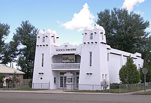
Even during the Great Depression, a special building called the Yucca Theatre was built in 1931. Local businessman David M. Manning and his brother Jim built it. The theater has a unique style and still shows movies every Sunday today.
David M. Manning was a very important person in Hysham. He owned many businesses and helped build the city swimming pool and water system. He also built dams to improve irrigation. Manning also served in the Montana government for 52 years, helping with projects like bringing electricity to rural areas and building highways.
Climate
Hysham has a climate with hot summers. This is known as a "hot-summer humid continental climate."
| Climate data for Hysham Montana, 1991–2020 normals, extremes 1945–present | |||||||||||||
|---|---|---|---|---|---|---|---|---|---|---|---|---|---|
| Month | Jan | Feb | Mar | Apr | May | Jun | Jul | Aug | Sep | Oct | Nov | Dec | Year |
| Record high °F (°C) | 72 (22) |
75 (24) |
82 (28) |
97 (36) |
100 (38) |
107 (42) |
111 (44) |
108 (42) |
105 (41) |
93 (34) |
79 (26) |
70 (21) |
111 (44) |
| Mean maximum °F (°C) | 55.9 (13.3) |
59.2 (15.1) |
71.7 (22.1) |
80.7 (27.1) |
86.6 (30.3) |
93.6 (34.2) |
98.4 (36.9) |
96.7 (35.9) |
91.9 (33.3) |
81.5 (27.5) |
67.9 (19.9) |
56.6 (13.7) |
99.3 (37.4) |
| Mean daily maximum °F (°C) | 34.7 (1.5) |
38.7 (3.7) |
50.5 (10.3) |
60.5 (15.8) |
69.8 (21.0) |
78.7 (25.9) |
87.6 (30.9) |
86.0 (30.0) |
75.3 (24.1) |
60.4 (15.8) |
46.7 (8.2) |
36.2 (2.3) |
60.4 (15.8) |
| Daily mean °F (°C) | 23.6 (−4.7) |
27.0 (−2.8) |
37.1 (2.8) |
46.8 (8.2) |
56.1 (13.4) |
65.2 (18.4) |
72.5 (22.5) |
70.6 (21.4) |
60.4 (15.8) |
47.3 (8.5) |
34.9 (1.6) |
25.4 (−3.7) |
47.2 (8.4) |
| Mean daily minimum °F (°C) | 12.4 (−10.9) |
15.3 (−9.3) |
23.8 (−4.6) |
33.0 (0.6) |
42.5 (5.8) |
51.7 (10.9) |
57.5 (14.2) |
55.1 (12.8) |
45.5 (7.5) |
34.2 (1.2) |
23.1 (−4.9) |
14.7 (−9.6) |
34.1 (1.1) |
| Mean minimum °F (°C) | −15.1 (−26.2) |
−9.3 (−22.9) |
0.7 (−17.4) |
18.0 (−7.8) |
28.5 (−1.9) |
40.4 (4.7) |
48.6 (9.2) |
44.2 (6.8) |
31.8 (−0.1) |
17.1 (−8.3) |
0.8 (−17.3) |
−8.7 (−22.6) |
−24.1 (−31.2) |
| Record low °F (°C) | −48 (−44) |
−38 (−39) |
−36 (−38) |
4 (−16) |
14 (−10) |
29 (−2) |
37 (3) |
32 (0) |
19 (−7) |
−9 (−23) |
−31 (−35) |
−46 (−43) |
−48 (−44) |
| Average precipitation inches (mm) | 0.61 (15) |
0.58 (15) |
0.80 (20) |
1.72 (44) |
2.47 (63) |
2.22 (56) |
1.51 (38) |
1.16 (29) |
1.40 (36) |
1.38 (35) |
0.59 (15) |
0.48 (12) |
14.92 (378) |
| Average snowfall inches (cm) | 8.3 (21) |
5.4 (14) |
5.6 (14) |
2.5 (6.4) |
0.8 (2.0) |
0.0 (0.0) |
0.0 (0.0) |
0.0 (0.0) |
0.1 (0.25) |
2.7 (6.9) |
4.2 (11) |
7.5 (19) |
37.1 (94.55) |
| Average precipitation days (≥ 0.01 in) | 5.1 | 4.9 | 5.8 | 7.3 | 8.8 | 8.6 | 6.1 | 4.5 | 5.3 | 6.4 | 4.6 | 4.7 | 72.1 |
| Average snowy days (≥ 0.1 in) | 4.0 | 3.8 | 2.3 | 1.0 | 0.2 | 0.0 | 0.0 | 0.0 | 0.0 | 1.0 | 2.5 | 3.8 | 18.6 |
| Source 1: NOAA | |||||||||||||
| Source 2: National Weather Service | |||||||||||||
Population of Hysham
| Historical population | |||
|---|---|---|---|
| Census | Pop. | %± | |
| 1920 | 360 | — | |
| 1930 | 258 | −28.3% | |
| 1940 | 392 | 51.9% | |
| 1950 | 410 | 4.6% | |
| 1960 | 494 | 20.5% | |
| 1970 | 373 | −24.5% | |
| 1980 | 449 | 20.4% | |
| 1990 | 361 | −19.6% | |
| 2000 | 330 | −8.6% | |
| 2010 | 312 | −5.5% | |
| 2020 | 276 | −11.5% | |
| U.S. Decennial Census | |||
Hysham's Population in 2010
In 2010, Hysham had 312 people living in 145 households. Most people were White (92.6%). About 20.7% of households had children under 18. The average age in Hysham was 52.8 years old.
Education in Hysham
Students in Hysham go to Hysham Public Schools from kindergarten through 12th grade. The sports teams at Hysham High School are called the Rebels.
Notable People from Hysham
- Cass Bauer-Bilodeau, a former women's basketball player, was born in Hysham.
- Lee Nye, a photographer, was born in Hysham.
See also
 In Spanish: Hysham (Montana) para niños
 | William Lucy |
 | Charles Hayes |
 | Cleveland Robinson |


