
Ihuatzio facts for kids
Quick facts for kids
Ihuatzio
|
|
|---|---|
|
Locality
|
|

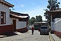
Main plaza of Ihuatzio
|
|

Ihuatzio
Location in Michoacán

Ihuatzio
Location in Mexico
|
|
| Country | |
| State | |
| Municipality | Tzintzuntzan |
| Area | |
| • Total | 1.40 km2 (0.54 sq mi) |
| Elevation | 2,052 m (6,732 ft) |
| Population
(2020)
|
|
| • Total | 3,950 |
| • Density | 2,821/km2 (7,310/sq mi) |
| Time zone | UTC-6 (ZC) |
| • Summer (DST) | UTC-5 |
| Postal code |
58442
|
Ihuatzio is a town in the Mexican state of Michoacán. Its name means "Land of Coyotes" in the Purépecha language. The town is located near Lake Pátzcuaro.
Ihuatzio was once the capital city of the powerful Purépecha kingdom. It served as the capital until the kingdom's center moved to Tzintzuntzan. In 2020, about 3,950 people lived in Ihuatzio.
Contents
Where is Ihuatzio?
Ihuatzio is found on the southeast side of Lake Pátzcuaro. It is about 8 kilometers (5 miles) southwest of the town of Tzintzuntzan. The town is located high up, about 2,052 meters (6,732 feet) above sea level.
What is the Climate Like?
Ihuatzio has a subtropical highland climate. This means it has mild temperatures all year round. It also has a wet season and a dry season.
The driest month is December, with only about 22 mm (0.8 inches) of rain. The wettest month is July, which gets a lot of rain, around 355 mm (14 inches).
| Climate data for Ihuatzio | |||||||||||||
|---|---|---|---|---|---|---|---|---|---|---|---|---|---|
| Month | Jan | Feb | Mar | Apr | May | Jun | Jul | Aug | Sep | Oct | Nov | Dec | Year |
| Mean daily maximum °C (°F) | 21.0 (69.8) |
22.8 (73.0) |
24.5 (76.1) |
26.7 (80.1) |
26.1 (79.0) |
23.0 (73.4) |
21.7 (71.1) |
21.9 (71.4) |
21.5 (70.7) |
21.7 (71.1) |
21.4 (70.5) |
21.0 (69.8) |
22.8 (73.0) |
| Daily mean °C (°F) | 14.1 (57.4) |
15.4 (59.7) |
16.8 (62.2) |
18.9 (66.0) |
19.0 (66.2) |
17.5 (63.5) |
16.5 (61.7) |
16.6 (61.9) |
16.3 (61.3) |
16.0 (60.8) |
15.2 (59.4) |
14.4 (57.9) |
16.4 (61.5) |
| Mean daily minimum °C (°F) | 9.0 (48.2) |
9.9 (49.8) |
11.1 (52.0) |
13.0 (55.4) |
13.6 (56.5) |
13.3 (55.9) |
12.7 (54.9) |
12.6 (54.7) |
12.3 (54.1) |
11.4 (52.5) |
10.1 (50.2) |
9.5 (49.1) |
11.5 (52.8) |
| Average rainfall mm (inches) | 35 (1.4) |
31 (1.2) |
32 (1.3) |
35 (1.4) |
140 (5.5) |
260 (10.2) |
355 (14.0) |
336 (13.2) |
293 (11.5) |
150 (5.9) |
56 (2.2) |
22 (0.9) |
1,745 (68.7) |
| Source: Climate-Data.org | |||||||||||||
Ancient History: The Archaeological Site
Ihuatzio is also the name of an important ancient site. This archaeological site is just north of the modern town. It sits on the southern slopes of a hill called “Cerro Tarhiata K'eri”.
The site is about 7 kilometers (4.3 miles) southeast of Tzintzuntzan. It is also on the southeastern shore of Lake Pátzcuaro. Scientists have found signs of people living here during two main time periods.
The first period was between 900 and 1200 CE. During this time, groups who spoke the Nahuatl language lived here. The second period was from 1200 to 1530 CE. This was when the Purépecha culture was at its strongest and most developed.
Galleries
-

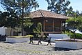
Inside of the Huatapera (enclosed patio) of Ihuatzio
-
Vasco de Quiroga street by the parish
-
Building in atrium of the Parish
-
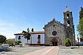
Local church


See also
 In Spanish: Ihuatzio para niños
