
Iller-Lech Plateau facts for kids
The Iller-Lech Plateau (also known as the Donau-Iller-Lech-Platte in German) is a special natural area in Germany. It's also sometimes called the Upper Swabian Plateau. This region is like a big, flat area that was shaped by ancient rivers and ice ages. It's located in the southern part of Germany, mainly in the states of Baden-Württemberg and Bavaria.

What's Around the Plateau?
The Iller-Lech Plateau has several interesting neighbors, each with its own unique features. Think of them as different "rooms" in Germany's big natural "house."
- To the Northwest: You'll find the Swabian Jura. The mighty Danube River acts like a natural fence, separating the plateau from this hilly area.
- To the Northeast: There's the Franconian Jura. Again, the Danube River helps mark the boundary between these two regions.
- To the East: This side borders the Lower Bavarian Uplands and the Isar-Inn Gravel Plateaus. The Lech River forms part of the border here.
- To the South: The plateau meets the Southern Alpine Foreland. The border here is marked by old piles of rock and dirt left behind by glaciers from the last big Ice Age. These are called terminal moraines.
Inside the Iller-Lech Plateau: Its Sub-regions
The Iller-Lech Plateau isn't just one big, uniform area. It's divided into many smaller parts, each with its own special look and history. These sub-regions were formed by different geological processes over millions of years, especially during the ice ages.

Here are some of the main sub-regions:
- 1: Danube-Ablach Plateaus: This area is an "Old Drift" landscape. This means it was shaped by very old glaciers and the materials they left behind (in Baden-Württemberg).
- 2: Danube Valley between Mengen and Ulm, Lower Riß Valley: These are wide river valleys carved out by the Danube and Riß rivers (in Baden-Württemberg).
- 3: Federsee Ried: This is a special wetland area, famous for its large lake, the Federsee (in Baden-Württemberg).
- 4: Western Plain of the Lower Riß: Here you'll find Tertiary hills (older hills formed before the Ice Age) and gravel deposits left by the ice age (in Baden-Württemberg).
- 5: Eastern Plain of the Lower Riß: Similar to the western plain, with Tertiary hills and older ice age gravels (in Baden-Württemberg).
- 6: Holzstöcke: This region is mainly made up of Tertiary hills (in Baden-Württemberg).
- 7 and 8: Western and Eastern Riß-Aitrach Plateaus: These are also "Old Drift" landscapes, shaped by ancient glaciers (in Baden-Württemberg).
- 9 and 10: Higher Plains of the Lower Iller Valley (south of Memmingen) and Lower Plains of the Lower Iller Valley (north of Memmingen): This is a large valley filled with gravel that was deposited during and after the ice ages (in Baden-Württemberg and Bavaria).
- 11 and 12: Upper and Lower Iller-Lech Gravel Plateaus: These areas have Tertiary hills with valleys created by rivers flowing from south to north (in Bavaria).
- 13: Donauried: A huge, flat fen plain next to the Danube River, formed during the Würm Ice Age (in Baden-Württemberg and Bavaria).
- 14 / 15: Zusam Plateau and Stauffenberg Region / Stauden Plateau (Stauden): These areas, together forming the Augsburg-Westliche Wälder Nature Park, feature Tertiary hills with valleys carved by rivers (in Bavaria).
- 16: Lech Valley: A large valley, also filled with gravel from the ice ages (in Bavaria).
- 17: Aindlingen Terrace: This region has Tertiary hills and a High gravel plateau (in Bavaria).
- 18 and 20: Lower and Upper Lech-Wertach Plain: This area is divided into lower terrace landscapes by the Wertach and Gennach rivers (in Bavaria).
- 19: Landsberg Plateau: A High gravel plateau that gently rises from north to south (in Bavaria).
- 21: Sachsenried and Denklingen Rotwald: This is a mostly forest landscape. In the north, it has high terrace gravels from the Lech River, and in the south, it's an "Old Drift" landscape (in Bavaria).
Images for kids
-
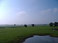
Bird habitat in the eastern Donauried

