
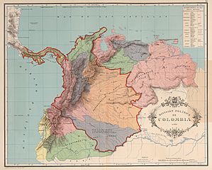
Image: AGHRC (1890) - Carta XI - División política de Colombia, 1824

Size of this preview: 746 × 600 pixels. Other resolutions: 299 × 240 pixels | 4,293 × 3,452 pixels.
Original image (4,293 × 3,452 pixels, file size: 5.8 MB, MIME type: image/jpeg)
Description: Political division of (Greater) Colombia in 1824. Map XI of the Geographic and Historic Atlas of the Republic of Colombia, 1890.
Title: AGHRC (1890) - Carta XI - División política de Colombia, 1824
Credit: Atlas geográfico e histórico de la República de Colombia, 1890. http://www.lablaa.org/blaavirtual/revistas/credencial/junio1993/junio1.htm
Author: Agustín Codazzi, Manuel Maria Paz, Felipe Pérez
Usage Terms: Public domain
License: Public domain
Attribution Required?: No
Image usage
The following image is a duplicate of this image (more details):
The following 7 pages link to this image:

All content from Kiddle encyclopedia articles (including the article images and facts) can be freely used under Attribution-ShareAlike license, unless stated otherwise.
_-_Carta_XI_-_División_política_de_Colombia,_1824.jpg)