
Image: Grand Canyon Aerial Kwagunt Butte, Malgosa Crest, Nankoweap Mesa

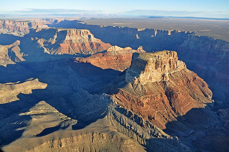
Description: This photo is a view from one of the routes in the National Park Service (NPS) Preferred Alternative within the Draft Environmental Impact Statement (EIS), Special Flight Rules Area in the Vicinity of Grand Canyon National Park (GCNP), illustrating the high quality scenic views and grandeur of GCNP. This view to the northeast shows Kwagunt Butte, Malgosa Crest and Nankoweap Mesa.. . The Draft EIS was developed to address the mandate of the 1987 National Parks Overflights Act to provide for substantial restoration of the natural quiet and experience of Grand Canyon National Park and for protection of public health and safety from adverse effects associated with aircraft overflights. Through the Draft EIS, the NPS is proposing a plan for managing helicopter and airplane flights over Grand Canyon. These flights currently carry more than 400,000 visitors above the canyon each year. Like all other uses in the park, air-tours play an important role in visitor enjoyment. But without better, more thoughtful management air-tour flights can interfere with the enjoyment of visitors on the ground. Air-tour flights also affect soundscape and other park resources of Grand Canyon's 1,902 square miles.. . The Draft EIS can be reviewed online at <a href="http://www.parkplanning.nps.gov/document.cfm?parkID=65&projectID=28052&documentID=38849" rel="nofollow">www.parkplanning.nps.gov/document.cfm?parkID=65&proje...</a> Comments can be submitted online at the same Web address (the preferred method), or mailed to Superintendent, Grand Canyon National Park, Attention: Office of Planning and Compliance, P.O. Box 129, Grand Canyon, Arizona 86023, or provided at one of the public meetings. Comments will be accepted through Monday, June 20, 2011.. . NPS Photo
Title: Grand Canyon Aerial Kwagunt Butte, Malgosa Crest, Nankoweap Mesa
Credit: Flickr: Grand Canyon DEIS Aerial: Kwagunt Butte, Malgosa Crest, Nankoweap Mesa
Author: Public Domain
Permission: This image, which was originally posted to Flickr, was uploaded to Commons using Flickr upload bot on 3 January 2013, 18:28 by Tillman. On that date, it was confirmed to be licensed under the terms of the license indicated. This file is licensed under the Creative Commons Attribution 2.0 Generic license. You are free: to share – to copy, distribute and transmit the work to remix – to adapt the work Under the following conditions: attribution – You must give appropriate credit, provide a link to the license, and indicate if changes were made. You may do so in any reasonable manner, but not in any way that suggests the licensor endorses you or your use. https://creativecommons.org/licenses/by/2.0 CC BY 2.0 Creative Commons Attribution 2.0 truetrue
Usage Terms: Public domain
License: Public domain
Attribution Required?: No
Image usage
The following 4 pages link to this image:
