
Image: Location map of Salem County, New Jersey

Size of this PNG preview of this SVG file: 700 × 600 pixels. Other resolution: 280 × 240 pixels.
Original image (SVG file, nominally 896 × 768 pixels, file size: 1.1 MB)
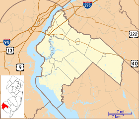
Description: This is a map of Salem County, New Jersey, USA which includes incorporated settlements, township borders, and major highways.
Title: Location map of Salem County, New Jersey
Credit: My own work, using custom-written MapScript applications with United States Census Bureau data
Author: Omnedon
Usage Terms: Public domain
License: Public domain
Attribution Required?: No
Image usage
The following 19 pages link to this image:
- Abel and Mary Nicholson House
- Aldine, New Jersey
- Alloway Township, New Jersey
- Brotmanville, New Jersey
- Carneys Point Township, New Jersey
- Centerton, Salem County, New Jersey
- Churchtown, New Jersey
- Daretown, New Jersey
- Deepwater, New Jersey
- Friendship, New Jersey
- Friesburg, New Jersey
- Hancock House (Lower Alloways Creek Township, New Jersey)
- Marshalltown, New Jersey
- Monroeville, New Jersey
- Norma, New Jersey
- Pedricktown, New Jersey
- Penton, New Jersey
- Quinton (CDP), New Jersey
- Whig Lane, New Jersey

All content from Kiddle encyclopedia articles (including the article images and facts) can be freely used under Attribution-ShareAlike license, unless stated otherwise.