
Image: Map Anasazi, Hohokam and Mogollon cultures-en

Size of this PNG preview of this SVG file: 487 × 599 pixels. Other resolution: 195 × 240 pixels.
Original image (SVG file, nominally 912 × 1,122 pixels, file size: 71 KB)
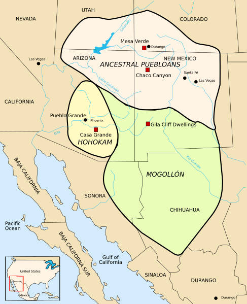
Description: Map of the extent of Anazasi, Hohokam and Mogollon settlements.
Title: Map Anasazi, Hohokam and Mogollon cultures-en
Credit: Map Anasazi, Hohokam and Mogollon cultures-fr.svg
Author: derivative work: Arkyan Map Anasazi, Hohokam and Mogollon cultures-fr.svg: Modifié par historicair 00:26, 9 April 2006 (UTC)
Usage Terms: Creative Commons Attribution-Share Alike 3.0
License: CC BY-SA 3.0
License Link: http://creativecommons.org/licenses/by-sa/3.0
Attribution Required?: Yes
Image usage
The following 17 pages link to this image:
- Anasazi Heritage Center
- Ancestral Puebloan dwellings
- Ansel Hall Ruin
- Basketmaker III Era
- Basketmaker culture
- Bears Ears National Monument
- Canyons of the Ancients Visitor Center and Museum
- Early Basketmaker II Era
- La Ferrería
- Late Basketmaker II Era
- List of Ancestral Puebloan dwellings in Colorado
- Pueblo III Period
- Pueblo II Period
- Pueblo IV Period
- Pueblo I Period
- Pueblo V Period
- Southwestern United States

All content from Kiddle encyclopedia articles (including the article images and facts) can be freely used under Attribution-ShareAlike license, unless stated otherwise.