
Image: Michigan Regions
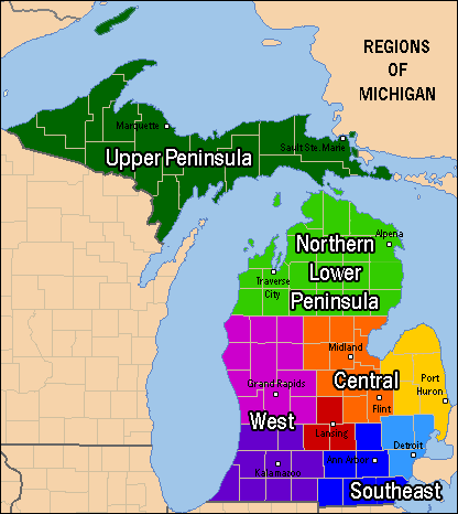
Description: Regions of the state of Michigan showing principal cities of each region. PLEASE NOTE THAT REGIONS ARE NOT EXACT. Transition zones exist between each realm, and color is used to show similarities and differences within these regions. (Example: red and orange have more in common than red and green). Some areas may be considered parts of multiple regions. (Example, Flint, Michigan could be it's own local region of Genessee County, Michigan or be a part of the Flint/Tri-Cities, Metro Detroit, or Central Michigan regions). Economic, geographic, and cultural similarities were all considered as documented on each region's wikipedia page. This map is a visual representation of the four principal regions (Central Michigan[1], Southeast Michigan[2], West Michigan[3], and Northern Michigan[4]) of Lower Michigan[5], along with the Upper Peninsula[6]as described in each region's respective article.
Title: Michigan Regions
Credit: This is my own work. Other maps were used as sources.[7][8][9][10][11]
Author: Michi906
Permission: All
Usage Terms: Creative Commons Attribution-Share Alike 3.0
License: CC BY-SA 3.0
License Link: http://creativecommons.org/licenses/by-sa/3.0
Attribution Required?: Yes
Image usage
The following 6 pages link to this image:
