
Image: United States 1862-1863-02

Size of this preview: 800 × 542 pixels. Other resolutions: 320 × 217 pixels | 1,000 × 677 pixels.
Original image (1,000 × 677 pixels, file size: 51 KB, MIME type: image/png)
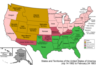
Description: Map of the states and territories of the United States as it was from 1862 to February 1863. On July 14 1862, Nevada Territory gained some land from Utah Territory. On February 24 1863, the Union split its own Arizona Territory from New Mexico Territory, including about half of the CSA's claimed Arizona Territory.
Title: United States 1862-1863-02
Credit: Own work
Author: Made by User:Golbez.
Permission: Own work, attribution required (Multi-license with GFDL and Creative Commons CC-BY 2.5)
Usage Terms: Creative Commons Attribution 2.5
License: CC BY 2.5
License Link: https://creativecommons.org/licenses/by/2.5
Attribution Required?: Yes
Image usage
The following 4 pages link to this image:

All content from Kiddle encyclopedia articles (including the article images and facts) can be freely used under Attribution-ShareAlike license, unless stated otherwise.