
Territorial evolution of Nevada facts for kids
The shape of the United States has changed a lot over time. The same is true for individual states, like Nevada. This article will explore how the land that is now Nevada became part of the U.S. and then a state. It's a story of different countries claiming the land and important agreements that drew new borders.


Contents
Nevada's Changing Borders
The land that makes up modern-day Nevada has a long history of being claimed by different nations. Before it became a U.S. state, it was part of much larger territories. Understanding these changes helps us see how Nevada got its unique shape and place in the country.
Early Claims: Spain and Mexico
For many years, the land that is now Nevada was claimed by Spain. This was part of their vast colonial empire in the Americas.
Spanish Control
From 1768 to 1804, parts of Nevada were included in a Spanish territory called Nueva California. Later, from 1804 to 1821, it was part of Alta California. This was a large area that also included much of present-day California.
A big part of Nevada was also known as the Gran Cuenca by the Spanish. This name refers to the large desert region with mountains and no outlet to the sea.
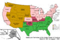
The Adams-Onís Treaty
In 1819, the Adams–Onís Treaty was signed. This agreement helped define the border between Spanish territories and the United States. It officially gave Florida to the U.S. and set the western boundary of the Louisiana Purchase. While it didn't directly change Nevada's borders, it was an important step in how the U.S. expanded westward.
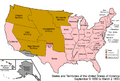
For a period between 1818 and 1846, a northern part of what is now Nevada was considered part of the Oregon Country. This was a large area that both the United States and Great Britain claimed. The Anglo-American Convention of 1818 set up a shared control of this region.
Mexican Independence
In 1821, Mexico gained its independence from Spain. This meant that the claims to Alta California and the Gran Cuenca transferred to Mexico. So, for a time, Nevada was part of Mexico.
The Mexican-American War
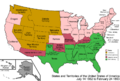
The Mexican-American War took place from 1846 to 1848. It was a conflict between the United States and Mexico. The war ended with the signing of the Treaty of Guadalupe Hidalgo in 1848. This treaty had a huge impact on the map of North America.
As a result of the treaty, Mexico gave up a massive amount of land to the United States. This land included California, Arizona, New Mexico, Utah, and all of present-day Nevada. This was a major moment in Nevada's history, as it officially became U.S. territory.
Becoming a U.S. Territory
After the Treaty of Guadalupe Hidalgo, the land that would become Nevada was unorganized U.S. territory. This meant it wasn't yet part of an official state or territory with its own government.
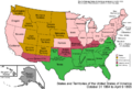
The Compromise of 1850
In 1850, the U.S. Congress passed the Compromise of 1850. This was a series of laws designed to settle disagreements over slavery in new territories. As part of this compromise, the Utah Territory was created. This new territory included most of what is now Nevada.
Early Settlements and Claims
Before the official territory was formed, some settlers tried to create their own areas. The "State of Deseret" was an unofficial government set up by Mormon pioneers in 1849. It claimed a very large area, including much of the future Nevada. However, it was never officially recognized by the U.S. government.
Another unofficial area was the "Nataqua Territory," which existed from 1856 to 1861. These were early attempts by settlers to organize themselves before the U.S. government established formal territories.
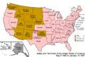
The Nevada Territory is Formed
On March 2, 1861, the U.S. Congress passed the Nevada Organic Act. This act officially created the Nevada Territory. It separated this land from the Utah Territory. This was a big step towards Nevada becoming its own state.
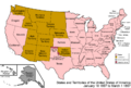
Expanding the Territory
The borders of the Nevada Territory weren't set in stone right away.
- On July 14, 1862, a section of land about 53 miles wide from the western part of the Utah Territory was added to the Nevada Territory. This moved Nevada's eastern border further east.
- On March 21, 1864, Congress passed the Nevada Enabling Act. This law allowed the Nevada Territory to begin the process of becoming a state.
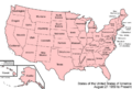
Nevada Becomes a State
Nevada officially became a state during the American Civil War.
Statehood Day
On October 31, 1864, Nevada officially joined the United States as a state. This day is still celebrated as Nevada Day. It was a fast process, partly because President Abraham Lincoln wanted more support for the Union during the war.
Final Border Changes
Even after becoming a state, Nevada's borders changed a couple more times:
- On May 5, 1866, another 53-mile strip of land from the western Utah Territory was transferred to Nevada. This pushed Nevada's eastern border even further east, giving it more land.
- On January 18, 1867, the northwestern corner of the Arizona Territory was transferred to Nevada. This added the southern tip of present-day Nevada, including the area around Laughlin, to the state.
These changes gave Nevada the borders we know today. From being part of Spanish and Mexican empires to a U.S. territory and finally a state, Nevada's territorial evolution is a fascinating part of American history.
Images for kids
-
An enlargeable map of the United States after the Treaty of Paris in 1789
-
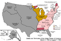
An enlargeable map of the United States after the Anglo-American Convention of 1818
-
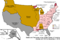
An enlargeable map of the United States after the Adams-Onís Treaty took effect in 1821
-
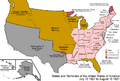
An enlargeable map of the United States after the Treaty of Guadalupe Hidalgo in 1848
-
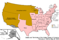
An enlargeable map of the United States after the Compromise of 1850
-
An enlargeable map of the United States after the Nevada Organic Act in 1861
-
An enlargeable map of the United States after the first Utah annexation in 1862
-
An enlargeable map of the United States after Nevada Statehood in 1864
-
An enlargeable map of the United States after the second Utah annexation in 1866
-
An enlargeable map of the United States after the Arizona annexation in 1867
-
An enlargeable map of the United States as it has been since 1959
