
Territorial evolution of Utah facts for kids
Have you ever wondered why states look the way they do on a map? Their shapes and sizes have changed a lot over time! This article explores the exciting story of how the State of Utah got its current borders. From ancient claims by Spain and Mexico to becoming a U.S. territory and finally a state, Utah's map has a fascinating history.
Contents
The Changing Map of Utah
Who Claimed Utah First?
Long before Utah became a state, different countries claimed its land. From 1562 to 1821, much of what is now Utah was part of Spain's vast territories in the Americas. This included areas known as Nueva Vizcaya and Santa Fé de Nuevo Méjico. Spain also claimed the Gran Cuenca region, which covers a large part of Utah.
Spain's claims changed over time. The Adams–Onís Treaty of 1819 helped define the border between Spanish lands and the United States. Then, in 1821, Mexico gained independence from Spain. This meant that the lands Spain once claimed, including present-day Utah, now belonged to Mexico.
Mexico's Time and the Treaty of Guadalupe Hidalgo
From 1821 to 1848, the land that would become Utah was part of Mexico. It was still considered part of Santa Fé de Nuevo México and the Gran Cuenca.
However, things changed dramatically after the Mexican–American War. This war ended with the signing of the Treaty of Guadalupe Hidalgo in 1848. As a result of this treaty, Mexico gave up a huge amount of land to the United States. This land included all of present-day Utah, along with California, Nevada, and parts of Arizona, New Mexico, Colorado, and Wyoming.
Becoming Part of the U.S.
After the Treaty of Guadalupe Hidalgo, the land that is now Utah became "unorganized territory" of the United States. This meant it was U.S. land, but it didn't have a formal government structure yet.
Many settlers, especially members of The Church of Jesus Christ of Latter-day Saints, began moving into this area. They wanted to create their own government. In 1849, they proposed creating a large, unofficial state called the State of Deseret. This proposed state was much bigger than modern Utah. It included parts of what are now Nevada, California, Arizona, New Mexico, Colorado, Idaho, and Wyoming. However, the U.S. Congress did not recognize the State of Deseret.
The Utah Territory is Born
In 1850, the U.S. Congress passed a series of laws known as the Compromise of 1850. As part of this compromise, the Territory of Utah was officially created on September 9, 1850. This territory was still very large, covering much of what the State of Deseret had claimed. The creation of the Utah Territory meant it now had a formal U.S. government, even though it wasn't a state yet.
How Utah Territory Shrank
Over the next few decades, the Utah Territory began to shrink as new territories and states were created around it.
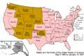
- 1861: The eastern part of the Utah Territory was used to create the new Territory of Colorado on February 28. Just a few days later, on March 2, the Territory of Nevada was formed from another western part of Utah. Also on March 2, a small northeastern corner of Utah was transferred to the Territory of Nebraska.
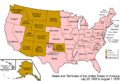
- 1862: On July 14, another 53 miles of the western Utah Territory were transferred to the Territory of Nevada.
- 1866: On May 5, yet another 53 miles of the Utah Territory were transferred to the State of Nevada, which had become a state in 1864.
- 1868: On July 25, the northeastern corner of the Utah Territory was incorporated into the new Territory of Wyoming.
These changes gradually shaped the Utah Territory into a size much closer to its current state boundaries.
The Jefferson Territory (Unofficial)
During this time, another unofficial territory, the Territory of Jefferson, existed from 1859 to 1861. This territory was mostly in what is now Colorado, but it also claimed a small part of the eastern Utah Territory. Like the State of Deseret, it was never officially recognized by the U.S. government.
Utah Becomes a State!
After many years as a territory, Utah finally became a state. The Utah Enabling Act was passed on July 16, 1894. This act allowed the people of Utah to write a state constitution and prepare for statehood.
Finally, on January 4, 1896, Utah was officially admitted to the Union as the 45th state. Its borders have remained the same ever since.
Images for kids
-
An enlargeable map of the United States after the Constitution of the United States was ratified on March 4, 1789.
-
An enlargeable map of the United States after the Treaty of Córdoba was signed on August 24, 1821.
-
An enlargeable map of the United States after the Treaty of Guadalupe Hidalgo was signed on February 2, 1848.
-
An enlargeable map of the United States after the creation of the proposed State of Deseret on July 2, 1849.
-
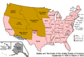
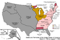
An enlargeable map of the United States after the creation of the Territory of New Mexico and the Territory of Utah on September 9, 1850.
-
An enlargeable map of the United States after the creation of the proposed Territory of Jefferson on October 24, 1859.
-

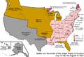
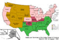
An enlargeable map of the United States after the creation of the Territory of Colorado on February 28, 1861.
-
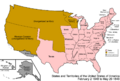
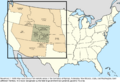
An enlargeable map of the United States after the creation of the Territory of Nevada on March 2 1861.
-
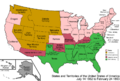
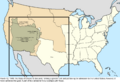
An enlargeable map of the United States after the annexation of a western portion of the Territory of Utah on July 14 1862.
-
An enlargeable map of the United States after the annexation of another western portion of the Territory of Utah on May 5 1866.
-
An enlargeable map of the United States after the creation of the Territory of Wyoming on July 25, 1868.


