
Territorial evolution of New Mexico facts for kids

The land that is now the State of New Mexico has a long and exciting history. Many different countries and governments have claimed or controlled this area over hundreds of years. This article will show you how New Mexico's borders and rulers changed through time.
Contents
New Mexico's Changing Borders: A Timeline
This timeline shows how the land of New Mexico was claimed and divided by different groups throughout history. It's like watching a map change over time!
Early Claims by Spain and France
- Spain's First Claims (1562–1821):
- Nueva Vizcaya: Spain first claimed parts of this land in 1562.
- Santa Fe de Nuevo México: A larger Spanish territory called New Mexico was established in 1598.
- This period ended when Mexico became independent from Spain in 1821 with the Treaty of Córdoba.
- France's Claim (1682–1764):
- Louisiane: France claimed a huge area called Louisiana in 1682, which included parts of modern New Mexico.
- France secretly gave Louisiana to Spain in 1762 through the Treaty of Fontainebleau.
- Louisiane: France claimed a huge area called Louisiana in 1682, which included parts of modern New Mexico.
- Spain Gets Louisiana Back (1764–1803):
- Luisiana: Spain officially took control of Louisiana in 1764.
- In 1800, Spain secretly gave Louisiana back to France with the Third Treaty of San Ildefonso.
- Luisiana: Spain officially took control of Louisiana in 1764.
- France's Short Claim (1803):
- Louisiane: France briefly owned Louisiana again in 1803.
- Soon after, France sold this vast territory to the United States in the famous Louisiana Purchase of 1803.
- Louisiane: France briefly owned Louisiana again in 1803.
Mexico and Texas Enter the Scene
- Mexico's Rule (1821–1848):
- Santa Fé de Nuevo México: After gaining independence from Spain, Mexico controlled New Mexico.
- This ended in 1848 with the Treaty of Guadalupe Hidalgo after the Mexican–American War.
- Santa Fé de Nuevo México: After gaining independence from Spain, Mexico controlled New Mexico.
- Texas's Disputed Claim (1836–1845):
- Republic of Texas: When Texas became an independent country, it claimed land east of the Rio Grande river. This area included parts of New Mexico.
- Texas joined the United States in 1845, an event known as the Texas Annexation.
- Republic of Texas: When Texas became an independent country, it claimed land east of the Rio Grande river. This area included parts of New Mexico.
New Mexico Becomes Part of the U.S.
- Early U.S. Territories (1803–1836):
- Unorganized territory: After the Louisiana Purchase, some parts of New Mexico were initially unorganized U.S. land.
- District of Louisiana: A temporary government was set up in 1804.
- Territory of Louisiana: This larger territory was formed in 1805.
- Territory of Missouri: In 1812, the area became part of the Missouri Territory.
- Territory of Arkansaw: Later, some parts were included in the Arkansas Territory from 1819.
- The Adams–Onís Treaty of 1819 helped define the border between U.S. and Spanish lands.
- After the Mexican-American War (1845–1850):
- Disputed territory: After Texas joined the U.S., the land it claimed in New Mexico was still debated.
- The Compromise of 1850 helped settle these border arguments.
- Mexican–American War: During this war (1846–1848), the U.S. took control of New Mexico.
- U.S. Military Province of New Mexico: The U.S. military governed the area briefly.
- U.S. Provisional Government of New Mexico: A temporary U.S. government was set up.
- Unorganized territory: After the Treaty of Guadalupe Hidalgo in 1848, more land became unorganized U.S. territory.
- State of Deseret: A group of settlers tried to create their own state here, but it was not officially recognized.
- Disputed territory: After Texas joined the U.S., the land it claimed in New Mexico was still debated.
- The Territory of New Mexico (1850–1912):
- Territory of New Mexico: In 1850, the official U.S. Territory of New Mexico was created.
- The Gadsden Purchase of 1853 added more land to the southern part of the territory.
- During the American Civil War (1861–1865), some southern parts were claimed by the Confederacy as Arizona Territory (CSA).
- Territory of New Mexico: In 1850, the official U.S. Territory of New Mexico was created.
- New Mexico Becomes a State (1912–Present):
- State of New Mexico: Finally, on January 6, 1912, New Mexico officially became the 47th state of the United States.
Maps
These maps show how the borders of the United States and the area of New Mexico changed over time. You can see how different claims and purchases shaped the land we know today.
-
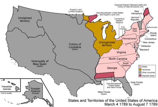
A map of the United States after its Constitution was approved on March 4, 1789.
-
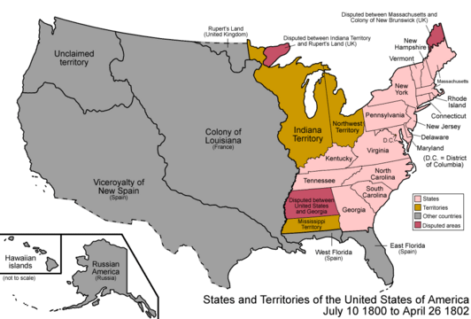
A map of the U.S. after Spain secretly gave Louisiana to France on October 1, 1800.
-
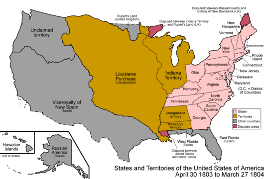
A map of the U.S. after the Louisiana Purchase took effect on December 20, 1803.
-
A map of the U.S. after the District of Louisiana was created on March 26, 1804.
-
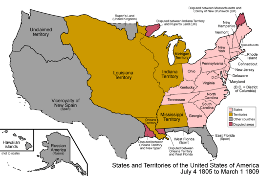
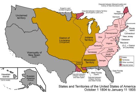
A map of the U.S. after the Territory of Louisiana was created on March 3, 1805.
-
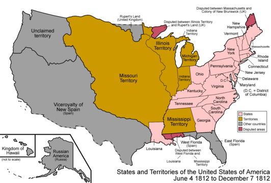
A map of the U.S. after the Territory of Missouri was created on June 4, 1812.
-
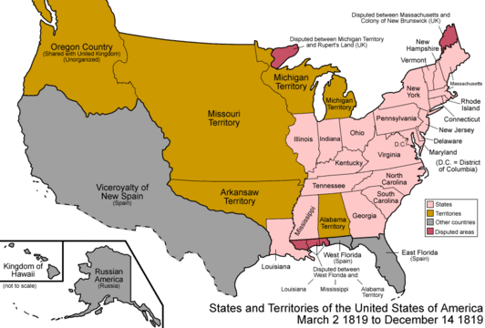
A map of the U.S. after the Territory of Arkansaw was created on March 2, 1819.
-
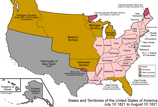
A map of the U.S. after the Adams–Onís Treaty took effect on February 22, 1821.
-
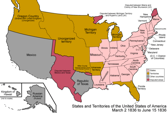
Territorial claims of the Republic of Texas, May 2, 1836.
-
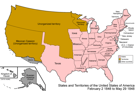
A map of the U.S. after the Treaty of Guadalupe Hidalgo was signed on February 2, 1848.
-
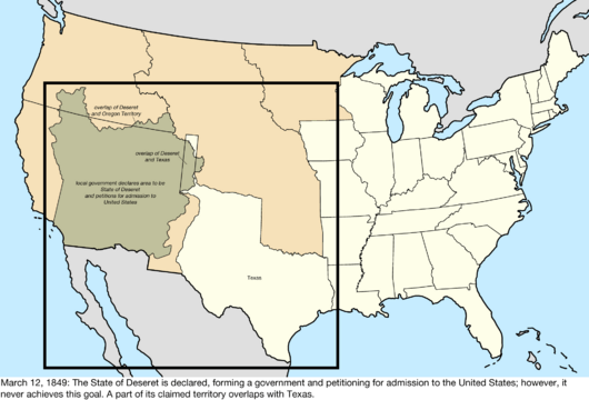
A map of the U.S. after the temporary State of Deseret was created on July 2, 1849.
-

A map of the U.S. after the Territory of New Mexico and the Territory of Utah were created on September 9, 1850.
-
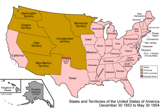
A map of the U.S. after the Gadsden Purchase on December 30, 1853.
-
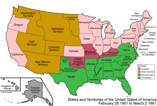
A map of the U.S. after the Territory of Colorado was created on February 28, 1861.
-

A map of the U.S. after the Confederate Territory of Arizona was created on February 24, 1862.
-
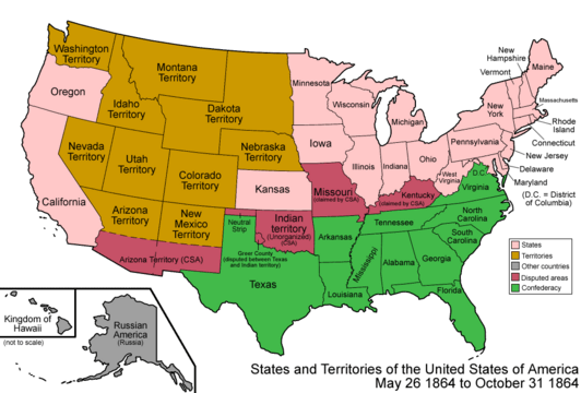
A map of the U.S. after the Territory of Arizona was created on June 19, 1862.
-
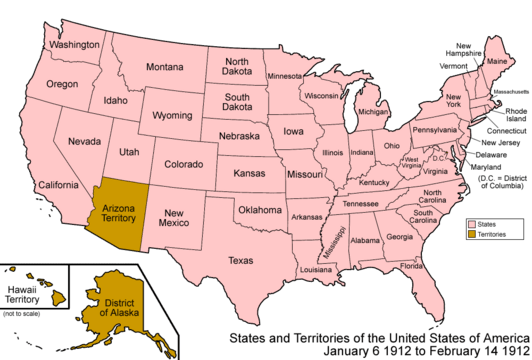
A map of the U.S. after New Mexico joined the Union on January 6, 1912.


