Inavale, Nebraska facts for kids
Quick facts for kids
Inavale, Nebraska
|
|
|---|---|

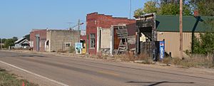
Blaine Street (U.S. Route 136) in Inavale,
October 2013 |
|
| Country | United States |
| State | Nebraska |
| County | Webster |
| Area | |
| • Total | 0.33 sq mi (0.86 km2) |
| • Land | 0.33 sq mi (0.86 km2) |
| • Water | 0.00 sq mi (0.00 km2) |
| Elevation | 1,739 ft (530 m) |
| Population
(2020)
|
|
| • Total | 66 |
| • Density | 197.60/sq mi (76.32/km2) |
| Time zone | UTC-6 (Central (CST)) |
| • Summer (DST) | UTC-5 (CDT) |
| ZIP codes |
68952
|
| FIPS code | 31-23725 |
| GNIS feature ID | 2583882 |
Inavale is a small community in Webster County, Nebraska, in the United States. It is known as a census-designated place, which means it's an area identified by the U.S. Census Bureau for statistical purposes.
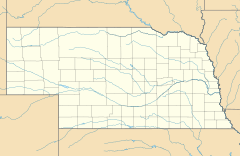
Inavale is located in the western part of Webster County. You can find it along U.S. Route 136. This road is west of Red Cloud, which is the main town in Webster County.
The land where Inavale sits is about 1,736 feet (529 meters) above sea level. The name "Inavale" comes from its location "in a vale," which means in a valley or hollow.
History of the Post Office
A post office was first opened in Inavale in 1873. It served the community for many years. However, the post office closed down in 1994. Even though the post office is gone, Inavale still uses the ZIP code 68952.
The number of people living in Inavale is counted by the U.S. Census Bureau.
Population Count
According to the 2020 Census, 66 people live in Inavale.
| Historical population | |||
|---|---|---|---|
| Census | Pop. | %± | |
| 2020 | 66 | — | |
| U.S. Decennial Census | |||
See also
 In Spanish: Inavale (Nebraska) para niños
 | Dorothy Vaughan |
 | Charles Henry Turner |
 | Hildrus Poindexter |
 | Henry Cecil McBay |


