Indian Stream facts for kids
Quick facts for kids Indian Stream |
|
|---|---|

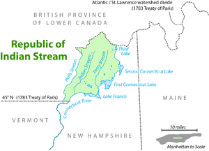
Map showing the Republic of Indian Stream (1832–1835) with Indian Stream near center of the green area
|
|
| Country | United States |
| State | New Hampshire |
| County | Coos |
| Town | Pittsburg |
| Physical characteristics | |
| Main source | Confluence of East and West Branches Pittsburg 1,420 ft (430 m) 45°12′9″N 71°20′14″W / 45.20250°N 71.33722°W |
| River mouth | Connecticut River Pittsburg 1,158 ft (353 m) 45°2′32″N 71°26′33″W / 45.04222°N 71.44250°W |
| Length | 19.1 mi (30.7 km) |
Indian Stream is a river in New Hampshire, United States. It is about 19.1 miles (30.7 km) long. This river flows into the Connecticut River. It starts in the mountains of northern New Hampshire. This area is in Coos County, very close to the Canada–United States border.
The land around Indian Stream was once part of a big argument. This argument was about where the border between the United States and Canada should be. For a short time, the people living there even tried to create their own tiny country!
What is Indian Stream?
Indian Stream is a tributary of the Connecticut River. A tributary is a smaller river or stream that flows into a larger river. Indian Stream begins where its East Branch and West Branch meet. This meeting point is in Pittsburg.
The river then flows generally south-southwest. It joins the Connecticut River about 2 miles (3 km) downstream from the village of Pittsburg. The river is an important part of the natural landscape in northern New Hampshire.
A Tiny Country: The Republic of Indian Stream
In the 1830s, the area around Pittsburg had a strange problem. No one was sure if it belonged to the United States or to Canada. This was because of an old agreement called the Treaty of Paris (1783). This treaty ended the American Revolutionary War. But it had some unclear parts about the border.
Because of this confusion, the people living in the Indian Stream area decided to take action. From 1832 to 1835, they declared themselves independent. They called their new "country" the Republic of Indian Stream. It was a very small, self-governing area.
How the Border Problem Was Fixed
The border argument was finally settled in 1842. This happened with a new agreement called the Webster–Ashburton Treaty. This treaty clearly defined the border between the United States and Canada.
As a result, the land around Indian Stream officially became part of New Hampshire. This included the river itself and the land east of another stream called Halls Stream. This agreement made sure that the area around Indian Stream was clearly part of the United States.
 | Audre Lorde |
 | John Berry Meachum |
 | Ferdinand Lee Barnett |


