Indigirka facts for kids
Quick facts for kids Indigirka |
|
|---|---|

At Ust-Nera
|
|
 |
|
| Country | Russia |
| Physical characteristics | |
| Main source | Confluence of the Tuora-Yuryakh and Taryn-Yuryakh 792 metres (2,598 ft) |
| River mouth | East Siberian Sea 71°26′32″N 150°51′39″E / 71.4422°N 150.8608°E |
| Length | 1,726 km (1,072 mi) |
| Basin features | |
| Basin size | 360,400 km2 (139,200 sq mi) |
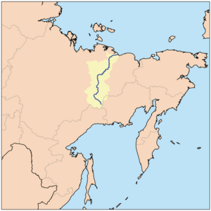
The Indigirka River is a long and important river in the Sakha Republic in Russia. It flows between two other big rivers, the Yana to its west and the Kolyma to its east. The Indigirka is about 1,726 kilometers (1,072 miles) long. Its basin, which is the area of land where all the water flows into the river, covers about 360,000 square kilometers (139,000 square miles).
Contents
History of the Indigirka River
Early Explorers and Settlements
The Indigirka River region has a rich history. The small village of Russkoye Ustye is located on the river's delta. This village is famous for its unique culture. The people living there are descendants of Russian settlers who arrived centuries ago. Some historians believe these settlers, called Pomors, came in the early 1600s.
Many explorers helped map and understand the Indigirka. In 1638, explorer Ivan Rebrov reached the river. Around the same time, Elisei Buza found an overland path to the Indigirka river system (a group of rivers that flow into each other). Poznik Ivanov also crossed mountains to reach the Indigirka. In 1642, Mikhail Stadukhin arrived at the river by land from the Lena River.
Zashiversk was an important outpost for Russia when they first started settling the area. However, it was later abandoned in the 1800s. Other old settlements like Podshiversk and Uyandinskoye Zimov'ye are also no longer inhabited.
Geological Surveys and Discoveries
From 1892 to 1894, Baron Eduard Von Toll led important geological surveys. He studied the rocks and land in the Indigirka basin for the Russian Academy of Sciences. His expedition traveled about 25,000 kilometers (15,500 miles). They also surveyed 4,200 kilometers (2,600 miles) of rivers.
Course of the Indigirka River
Where the River Begins
The Indigirka River starts where two smaller rivers meet. These are the 251-kilometer (156-mile) long Tuora-Yuryakh and the 63-kilometer (39-mile) long Taryn-Yuryakh. Both of these rivers begin on the slopes of the Khalkan Range mountains.
Journey Through Mountains and Lowlands
At first, the Indigirka flows northwest through the Yana-Oymyakon Highlands. It then turns north and cuts through parts of the Chersky Range. When it crosses the Chemalgin Range, the river becomes narrow. It flows into a deep gorge, creating fast-moving rapids.
When the Moma river joins from the southeast, the Indigirka enters the Momo-Selennyakh Depression. This is a wide basin between mountains. Here, the river's valley gets wider. The Indigirka then cuts through the Moma Range and flows northeast. It winds across the Aby Lowland and widens to about 500 meters (1,640 feet).
After flowing past the Polousny Range and the Ulakhan-Chistay Range, it flows north. It passes the Kondakov Plateau and crosses the Yana-Indigirka Lowland. This lowland is part of the larger East Siberian Lowland. Further north, the land becomes very flat. About 130 kilometers (81 miles) before reaching the sea, the Indigirka splits into many branches. These branches form a large delta that is about 5,500 square kilometers (2,120 square miles) wide. The river's water finally flows into the Kolyma Bay in the East Siberian Sea. The Gusinaya Bay is located northwest of the Indigirka's mouths.
The Indigirka River freezes over in October and stays frozen until May or June.
River Branches and Tributaries
A tributary is a smaller river or stream that flows into a larger river. Here are the main tributaries of the Indigirka, listed from where the river starts to where it ends:
- Khastakh (Tuora-Yuryakh) (flows in from the left)
- Taryn-Yuryakh (flows in from the right)
- Kuydusun (left)
- Kyuyente (left)
- Elgi (left)
- Nera (right)
- Chibagalakh (left)
- Moma (right)
- Selennyakh (left)
- Druzhina (left)
- Badyarikha (right)
- Uyandina (left)
- Shangina (right)
- Bolshaya Ercha (right)
- Allaikha (left)
- Byoryolyokh (left, into Russko-Ustyinskaya)
- Shandrin (right, into Kolymskaya)
Ports, Settlements, and Economy
Important Places Along the River
Several important towns are located along the Indigirka River. These include:
- Khonuu
- Druzhina
- Chokurdakh
- Tabor
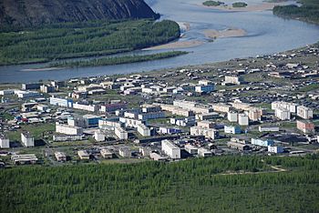
The area around the Indigirka River is known for gold prospecting, which means searching for gold. Ust-Nera is a major center for gold mining and is the largest town on the river.
Fish Life in the Indigirka
The Indigirka River is full of many different types of fish. Some of the most valuable fish found here are freshwater whitefish species. These include fish like vendace, chir, muksun, inconnu (also called nelma), and omul.
Mouths of the Indigirka River
The River Delta and Its Arms
The Indigirka forms a very large river delta as it gets close to the sea. A delta is an area of land where a river splits into many smaller streams before flowing into a larger body of water. The Indigirka's delta has many streams, which are called protoka (river arms) on Russian maps, and islands.
About 100 kilometers (62 miles) before it reaches the East Siberian Sea, the river divides into two main streams that flow northeast. The left (western) arm is called the Russko-Ustyinskaya Protoka. The right arm is called the Srednyaya Protoka, which means "Middle Arm" in Russian. Further downstream, a third major arm, the Kolymskaya Protoka, splits off from the Srednyaya Protoka on its right side. This is why the Srednyaya Protoka is called the "Middle Arm."
The names of these arms often describe their location. The Kolymskaya Protoka is on the eastern side of the delta, closer to the Kolyma River. The Russko-Ustyinskaya Protoka is on the western side, closer to the part of Russia that is more like European Russia. It is also linked to the old Russian village of Russkoye Ustye located there.
Islands in the Delta
The channels of the delta create several flat islands. Here are some of the main ones, listed from east to west:
- Usun-Ary 71°23′13″N 151°15′18″E / 71.387°N 151.255°E is a long island along the coast east of the Srednyaya mouth. It is 12 kilometers (7.5 miles) long and 2.7 kilometers (1.7 miles) wide.
- Uparovskiy Island 71°34′55″N 151°11′46″E / 71.582°N 151.196°E is completely separate and lies 11 kilometers (6.8 miles) offshore from the Srednyaya mouth. It is about 2 kilometers (1.2 miles) long and 1 kilometer (0.6 miles) wide.
- Ploskiy Island 71°28′48″N 150°53′24″E / 71.480°N 150.890°E is the farthest island offshore in a group of islands at the Srednyaya mouth. It is shaped like a C and is about 3 kilometers (1.9 miles) long.
- Bolshoy Fedorovskiy 71°31′59″N 150°30′36″E / 71.533°N 150.510°E lies between the two main mouths of the Indigirka. It is 6 kilometers (3.7 miles) long and up to 4 kilometers (2.5 miles) wide.
- Vkodnoy and Oleniy islands are right at the Prot. Russko Ust'inskaya mouth 71°32′46″N 150°15′58″E / 71.546°N 150.266°E. Both are about 4 kilometers (2.5 miles) long.
- Krestovyy Island 71°26′49″N 149°45′58″E / 71.447°N 149.766°E is quite isolated. It lies directly south of the Lopatka Peninsula, about 10 kilometers (6.2 miles) offshore to the northwest of the main Indigirka mouths. It is 6 kilometers (3.7 miles) long and 1.6 kilometers (1 mile) wide.
See also
 In Spanish: Río Indigirka para niños
- Cave lion cubs Boris and Sparta, found on the banks of the Tirekhtyakh tributary
- List of rivers of Russia
- Yana-Oymyakon Highlands§Hydrography
 | George Robert Carruthers |
 | Patricia Bath |
 | Jan Ernst Matzeliger |
 | Alexander Miles |

