
Intibucá, Intibucá facts for kids
Quick facts for kids
Intibucá
La ciudad del manto blanco
|
|
|---|---|
|
Municipality
|
|
_con_sus_maravillas_naturales_y_tradiciones_lencas.jpg) |
|

Intibucá, Intibucá
Location in Honduras
|
|
| Country | Honduras |
| Department | Intibucá |
| Head of parish | 1791 |
| Municipality of Gracias | 1866 |
| Municipality of Intibuca | 1883 |
| Government | |
| • Type | Democratic Municipality |
| Area | |
| • Total | 531 km2 (205 sq mi) |
| Elevation | 1,700 m (5,600 ft) |
| Population
(2023 projection)
|
|
| • Total | 70,092 |
| • Density | 132.00/km2 (341.9/sq mi) |
| Time zone | UTC-6 (Central America) |
| Postal code |
14000
|
| Municipality number | 1006 |
| Climate | Cfb |
Intibucá is a city and a municipality in the Intibucá region of Honduras. It is home to about 28,220 people (as of 2023). This city is an important place for travel and trade in the southwest of Honduras.
Intibucá is located high up, about 1,850 meters (6,070 feet) above sea level. Because of its high location, it often has cool and foggy weather. This is why it's nicknamed "La ciudad del manto blanco," which means "the city of the white mantle." The main way people make a living here is by growing potatoes. They even have an annual Festival de la Papa (Potato Festival) to celebrate it!
The city of Intibucá is very close to La Esperanza. They are like twin cities, separated only by a street. Intibucá is the older city, originally settled by the Lenca indigenous group. La Esperanza is newer and was settled by Ladino people. Even though they have separate local governments, people often call both cities "La Esperanza." People from Intibucá are called intibucanos, and those from La Esperanza are called esperanzanos.
Contents
Where is Intibucá Located?
The municipality of Intibucá shares its borders with several other areas:
- To the north: San Francisco de Ojuera and San Pedro Zacapa.
- To the south: Marcala and La Esperanza.
- To the east: Masaguara and Jesús de Otoro.
- To the west: Yamaranguila and La Esperanza.
The cities of La Esperanza and Intibucá are in a flat area within the Opalaca Mountain Range. Long ago, this area was likely a lake. Today, you can still find wet or swampy spots, which are clues that a lake used to be here.
Who Lives in Intibucá?
In 2013, the Intibucá municipality had a population of 56,017 people. Most of the people living here are Indigenous, especially the Lenca group.
- About 77% are Indigenous (mostly Lenca).
- About 20% are Mestizo (people of mixed European and Indigenous heritage).
- About 2% are White.
- Less than 1% are Afro-Honduran or Black or other groups.
A Look Back: Intibucá's History
People have lived in this region since ancient times. Long before Europeans arrived, indigenous groups mined obsidian (a type of volcanic glass) here. They used it to make tools and traded it with other groups across Mesoamerica.
When the Spanish arrived, the area was mainly home to the Lenca people. The Lenca adopted the Spanish language and religion. However, they kept many of their old traditions, like farming practices, myths, and beliefs. These traditions still define them as a unique group today.
The Auxíliaria de la Vara Alta
The Lenca people in Intibucá had a special political and religious group called the Auxíliaria de la Vara Alta. This group helped manage food supplies, collect taxes, and keep track of land ownership. They also worked to preserve the Lenca culture and traditions.
How Intibucá Became a City
Before the Spanish conquest, there were two main towns in this area: Lentercali and Eramani. The name Intibucá first appeared in a report in 1582. The Spanish crown appointed a mayor, Francisco de Cerdá, to govern the indigenous people.
In 1647, the area of Intibucá was officially defined to include villages with Lenca names. By 1791, Intibucá was already an important parish center. It became a village in 1848. Later, in 1866, it was made a municipality within the department of Gracias (which is now called Lempira). Finally, in 1883, Intibucá became a municipality in the newly formed Intibucá department.
The Twin Cities: Intibucá and La Esperanza
The areas of Intibucá and La Esperanza today are similar to the old towns of Lentercali and Eramani. Ladino merchants and ranchers moved into the area from other parts of Honduras, Guatemala, and El Salvador. They bought land from the indigenous people of Eramani and founded La Esperanza.
When the Intibucá department was created in 1883, La Esperanza became its capital. This led to some disagreements between the Lenca people of Intibucá and the Ladino people of La Esperanza, especially over land and religion. To avoid conflict, the Lenca people of Intibucá moved away from their town center. This included their church, built in 1790 (the oldest in the region), and their cemetery. These places are now within La Esperanza's borders. So, people from Intibucá cross into La Esperanza to go to church and bury their family members. They also share the central park, Parque López, which is now in La Esperanza.
Lenca Traditions Today
Most residents of Intibucá are still Lenca, even though many village names were changed to Catholic saints during colonial times. The Auxiliaria de la Vara Alta organization, while gone in other areas, continued in Intibucá and Yamaranguila into the 20th century. As it lost political power, it became more important for religious and cultural events.
One very important celebration is the Guancasco, held on February 2nd. This event celebrates the connections between villages. During the Guancasco, the patron saint of Intibucá, La Virgen de Candelaria, is carried to different villages each year. This celebration mixes Catholic traditions with ancient Lenca symbols like rods, masks, flags, and music from drums and chirimía (a type of flute). It represents a long history of agreements that brought peace.
Intibucá's Climate
Intibucá and La Esperanza have a cool, subtropical highland climate. This is typical for cities located at high altitudes. The weather is pleasant, and even cold by Honduran standards. The yearly temperature difference between the coldest month (December) and the warmest month (April) is only about 5°C (9°F). This climate is great for growing crops like potatoes, strawberries, blackberries, peaches, and many vegetables.
Seasons in Intibucá
Intibucá has two main seasons: a wet season and a dry season. However, locals often describe three seasons:
- Hot Season (Summer): From March to May. Temperatures can go above 25°C (77°F).
- Monsoon Season (Hurricane Season): From July to October. This season has high humidity, thunderstorms, and short, heavy rains, sometimes with hail.
- Cold Dry Season (Winter): From November to February. Nights can be freezing, and days are cool. Rains are usually light showers, and thick fogs are common. Temperatures during winter range from 10°C to 20°C (50°F to 68°F).
The average yearly temperature in Intibucá is about 16.4°C (61.5°F).
Rainfall
The city's rainfall is affected by the tropical monsoon.
- Dry Season: From November to April. February is the driest month, with only about 12 mm (0.5 inches) of rain.
- Wet Season: From May to October. September is the wettest month, with about 316 mm (12.4 inches) of rain.
The average yearly rainfall is 1548 mm (60.9 inches), and the average humidity is 75%.
| Climate data for La Esperanza, Honduras (1989-2024) | |||||||||||||
|---|---|---|---|---|---|---|---|---|---|---|---|---|---|
| Month | Jan | Feb | Mar | Apr | May | Jun | Jul | Aug | Sep | Oct | Nov | Dec | Year |
| Record high °C (°F) | 36.6 (97.9) |
33.0 (91.4) |
31.7 (89.1) |
32.0 (89.6) |
31.0 (87.8) |
34.0 (93.2) |
32.0 (89.6) |
32.8 (91.0) |
31.0 (87.8) |
29.0 (84.2) |
33.0 (91.4) |
29.6 (85.3) |
36.6 (97.9) |
| Mean daily maximum °C (°F) | 21.5 (70.7) |
23.1 (73.6) |
24.6 (76.3) |
25.6 (78.1) |
24.9 (76.8) |
24.1 (75.4) |
23.7 (74.7) |
24.0 (75.2) |
24.0 (75.2) |
22.6 (72.7) |
21.3 (70.3) |
21.1 (70.0) |
23.4 (74.1) |
| Daily mean °C (°F) | 15.9 (60.6) |
16.8 (62.2) |
17.9 (64.2) |
19.1 (66.4) |
19.5 (67.1) |
19.1 (66.4) |
18.8 (65.8) |
19.0 (66.2) |
19.0 (66.2) |
18.3 (64.9) |
17.0 (62.6) |
16.1 (61.0) |
18.0 (64.5) |
| Mean daily minimum °C (°F) | 10.5 (50.9) |
10.5 (50.9) |
11.2 (52.2) |
12.6 (54.7) |
14.0 (57.2) |
14.1 (57.4) |
13.9 (57.0) |
13.9 (57.0) |
14.1 (57.4) |
13.9 (57.0) |
12.7 (54.9) |
11.2 (52.2) |
12.7 (54.9) |
| Record low °C (°F) | 1.0 (33.8) |
−0.3 (31.5) |
1.5 (34.7) |
5.0 (41.0) |
6.5 (43.7) |
7.0 (44.6) |
8.4 (47.1) |
8.5 (47.3) |
9.2 (48.6) |
7.8 (46.0) |
3.7 (38.7) |
0.5 (32.9) |
−0.3 (31.5) |
| Average precipitation mm (inches) | 53.2 (2.09) |
42.8 (1.69) |
46.4 (1.83) |
60.2 (2.37) |
114.4 (4.50) |
118.1 (4.65) |
122.2 (4.81) |
140.3 (5.52) |
125.9 (4.96) |
123.6 (4.87) |
90.4 (3.56) |
89.3 (3.52) |
1,126.8 (44.37) |
| Average precipitation days (≥ 1.0 mm) | 1.0 | 1.1 | 1.3 | 3.7 | 9.2 | 14.1 | 10.4 | 12.2 | 15.4 | 10.7 | 4.4 | 1.6 | 85.2 |
| Source: NOAA | |||||||||||||
Villages and Neighborhoods
The municipality of Intibucá includes 20 villages (called aldeas) and 127 smaller settlements (called caseríos). The main urban area has 19 neighborhoods (called barrios).
List of Villages
Here are the 20 villages in the municipality:
- Intibucá
- Azacualpa
- El Naranjo
- El Pelón de Ologosí
- El Rodeo
- La Laguna de Chiligatoro
- La Sorto
- Malguara
- Manazapa
- Mixcure
- Monquecagua
- Pueblo Viejo
- Quebrada Honda
- Río Blanco
- Río Colorado
- Río Grande o El Nance
- San José
- San Nicolás
- San Pedro
- Santa Catarina
- Togopala
Images for kids
-
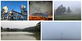
A view of Intibucá, showing its natural beauty and Lenca traditions.
See also
 In Spanish: Intibucá (municipio) para niños
