Inírida, Guainía facts for kids
Quick facts for kids
Inírida
|
||
|---|---|---|
|
Municipality and city
|
||

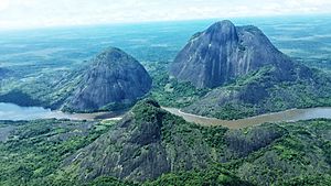
Mavecure Hills
|
||
|
||

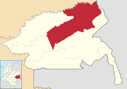
Location of the municipality and town of Inírida, Guainía in the Guainía Department of Colombia
|
||
| Country | ||
| Region | Amazon Region | |
| Department | Guainía Department | |
| Area | ||
| • Municipality and city | 15,970 km2 (6,170 sq mi) | |
| • Urban | 8.56 km2 (3.31 sq mi) | |
| Population
(2018 census)
|
||
| • Municipality and city | 31,514 | |
| • Density | 1.9733/km2 (5.1109/sq mi) | |
| • Urban | 20,279 | |
| Time zone | UTC-05 (Colombia Standard Time) | |
Inírida, once called Puerto Inírida, is an important city in Colombia. It is the capital of the Guainía Department. This city started as a small village named Obando in 1963. Later, in 1974, it was officially renamed Inírida. Most of the people living here are indigenous. The city had about 31,514 residents in 2018. This means about one-third of all the people in the Guainía department live in Inírida!
Contents
History of Inírida
Before the 1960s, the area where Inírida now stands was not very developed. Only a few indigenous people lived there. In the 1990s and 2000s, more people started to arrive. This happened because the area's natural resources were being used more. Efforts were made to help manage the growing population.
Geography of Inírida
Inírida is located in the llanos, which are wide, flat grasslands. It sits right where two rivers meet: the Inírida River and the Guaviare River. Most of the land around Inírida is flat, near the rivers. However, there are also some hills. The city is about 30 kilometers (18 miles) from the border with Venezuela.
Climate in Inírida
Inírida has a tropical rainforest climate. This means it is hot and rainy all year round. It gets a lot of rain, especially from April to August. Even in the drier months, there is still plenty of rainfall. The temperatures stay warm and steady throughout the year.
| Climate data for Inírida (Pto Inirida), elevation 100 m (330 ft), (1981–2010) | |||||||||||||
|---|---|---|---|---|---|---|---|---|---|---|---|---|---|
| Month | Jan | Feb | Mar | Apr | May | Jun | Jul | Aug | Sep | Oct | Nov | Dec | Year |
| Mean daily maximum °C (°F) | 32.7 (90.9) |
33.2 (91.8) |
33.0 (91.4) |
31.7 (89.1) |
30.4 (86.7) |
29.9 (85.8) |
29.9 (85.8) |
30.6 (87.1) |
31.7 (89.1) |
32.1 (89.8) |
32.0 (89.6) |
32.1 (89.8) |
31.6 (88.9) |
| Daily mean °C (°F) | 27 (81) |
27.4 (81.3) |
27.4 (81.3) |
26.7 (80.1) |
26.2 (79.2) |
25.8 (78.4) |
25.6 (78.1) |
26.0 (78.8) |
26.5 (79.7) |
26.7 (80.1) |
26.8 (80.2) |
26.9 (80.4) |
26.5 (79.7) |
| Mean daily minimum °C (°F) | 22.3 (72.1) |
22.7 (72.9) |
22.8 (73.0) |
22.9 (73.2) |
22.9 (73.2) |
22.6 (72.7) |
22.3 (72.1) |
22.5 (72.5) |
22.3 (72.1) |
22.6 (72.7) |
22.8 (73.0) |
22.6 (72.7) |
22.6 (72.7) |
| Average precipitation mm (inches) | 90.9 (3.58) |
127.4 (5.02) |
118.5 (4.67) |
293.7 (11.56) |
435.6 (17.15) |
504.4 (19.86) |
509.1 (20.04) |
398.9 (15.70) |
297.7 (11.72) |
224.3 (8.83) |
204.6 (8.06) |
123.0 (4.84) |
3,327.9 (131.02) |
| Average precipitation days | 9 | 10 | 13 | 19 | 25 | 25 | 25 | 23 | 19 | 17 | 15 | 12 | 206 |
| Average relative humidity (%) | 81 | 79 | 79 | 84 | 87 | 87 | 86 | 85 | 83 | 83 | 83 | 82 | 84 |
| Mean monthly sunshine hours | 213.9 | 177.8 | 170.5 | 135.0 | 120.9 | 123.0 | 139.5 | 161.2 | 174.0 | 176.7 | 168.0 | 182.9 | 1,943.4 |
| Mean daily sunshine hours | 6.9 | 6.3 | 5.5 | 4.5 | 3.9 | 4.1 | 4.5 | 5.2 | 5.8 | 5.7 | 5.6 | 5.9 | 5.3 |
| Source: Instituto de Hidrologia Meteorologia y Estudios Ambientales | |||||||||||||
Economy and Tourism in Inírida
The main ways people make a living in Inírida are through farming, fishing, and raising cattle. Many families grow food just for themselves. They also produce fiber from a palm tree called chiquichiqui. This fiber is used to make ropes. Another plant, called "Yaré" (a type of rattan), is used to make furniture and baskets.
Inírida is also becoming a popular place for tourists. Visitors come to enjoy activities like fishing, canoeing, sightseeing, and hiking. Because more tourists are visiting, new hotels and hostels have opened. Making handicrafts has also become an important business. The government helps support local artists and craftspeople.
People of Inírida
The people of Inírida come from different backgrounds. About 53% of the population are indigenous people. These include groups like the Kurripacos, Puinaves, and Piapocos. About 30% of the people are "colonizers," meaning they moved to Inírida from other parts of Colombia. The remaining 17% are other indigenous groups.
Transportation in Inírida
Getting to and around Inírida is an interesting experience!
Airports and Flights
The local airport is called César Gaviria Trujillo Airport. It is named after a former president of Colombia. The airport code is PDA. As of 2007, two airlines fly there. Satena has three flights a week to and from Bogotá and two flights a week to and from Villavicencio. Air Colombia flies twice a week from Villavicencio, stopping at Barrancominas, Guainía, before arriving in Inírida. This airline uses a special plane called a Douglas DC-3 that flies without stopping. There is also a cargo airline that flies twice a week from Bogotá. The airport used to be known as Aeropuerto Obando.
You can also travel to Inírida by river. However, these trips can take many hours or even days. They often cost almost as much as flying.
Public Transportation in Town
As more people have moved to Inírida, public transportation has grown. About 500 auto rickshaws are available. These are small, three-wheeled vehicles that offer a quick and cheap way to get around town. A ride usually costs around 50 US cents. For larger groups, there are also mini-vans. The cost for these is also about 50 US cents per person.
See also
 In Spanish: Inírida para niños
 | John T. Biggers |
 | Thomas Blackshear |
 | Mark Bradford |
 | Beverly Buchanan |


