Isla Calero facts for kids

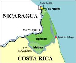
Map of the islands Calero, Brava and Portillos. The box delimits the yellow zone corresponding to the disputed region between Costa Rica and Nicaragua during 2010-2011, which was resolved by the International Court of Justice.
|
|
| Geography | |
|---|---|
| Location | San Juan River |
| Coordinates | 10°50′58″N 83°37′23″W / 10.8495°N 83.6231°W |
| Area | 151.6 km2 (58.5 sq mi) |
| Demographics | |
| Population | 0 |
Isla Calero (which means Calero Island in English) is the biggest island in Costa Rica. It's also the largest island found along the San Juan River. This river forms an important border between two countries: Nicaragua and Costa Rica.
The island is surrounded by water. To its north and west is the San Juan River. To the south and southeast, you'll find the Río Colorado of Costa Rica. And to the east and northeast, it meets the wide Caribbean Sea. Isla Calero is quite large, covering an area of about 151.6 square kilometers.
Contents
What is the Isla Calero Border Dispute?
Isla Calero is officially part of Costa Rica. However, in November 2010, a nearby island called Isla Portillos became the center of a big disagreement. Isla Portillos is a special place for nature, known as an ecological preserve.
Why did the border dispute start?
Nicaraguan troops entered Isla Portillos, which caused a lot of news coverage. This event brought back an old border argument between Costa Rica and Nicaragua that had started way back in 1850. The dispute was about a small area, about 3 kilometers long, on Isla Portillos. Nicaragua sometimes called this area Harbour Head Island.
For 50 years, Nicaragua's own maps showed this part of the land as belonging to Costa Rica. The border had been set by three important historical documents:
- The Cañas–Jerez Treaty
- The Cleveland Award
- The Alexander Award, given by E.P. Alexander
The Cañas–Jerez Treaty, signed in 1858, said that Nicaragua owned the San Juan River. But it also gave Costa Rica the right to use the river for trade and business.
How did the dispute change in 2010?
In 2010, Nicaragua started claiming that a small, sometimes-dry channel, about 3 kilometers south of the island's northern tip, was the actual border. This was different from the map that came with the 1897 Alexander Award, which showed the main San Juan River as the border.
In November 2010, Nicaraguan military forces cut down trees along this small channel and made it deeper. In December 2010, a commander named Edén Pastora even used Google Maps to try and prove Nicaragua's claim. However, Google quickly fixed the map error.
How was the border dispute resolved?
In March 2011, the International Court of Justice stepped in. This court is like a very important judge for countries. They made a temporary rule that both Costa Rica and Nicaragua should not send or keep people like civilians, security forces, or police in the disputed area.
However, Costa Rica was allowed to send teams of civilians to deal with environmental issues in the area. Nicaragua was also allowed to continue digging and clearing the San Juan River itself, because Nicaragua has control over the river.
Finally, on December 16, 2015, the International Court of Justice made its final decision. They ruled that the disputed land belonged to Costa Rica.
See also
 In Spanish: Isla Calero para niños
- 2010 Isla Calero dispute
- List of islands of Costa Rica
 | Tommie Smith |
 | Simone Manuel |
 | Shani Davis |
 | Simone Biles |
 | Alice Coachman |

