Ivanpah, California facts for kids
Quick facts for kids
Ivanpah
|
|
|---|---|

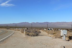
View of Ivanpah, with the Ivanpah Mountains in the distance
|
|
| Country | United States |
| State | California |
| County | San Bernardino |
| Elevation | 3,520 ft (1,070 m) |
| Time zone | UTC-8 (Pacific (PST)) |
| • Summer (DST) | UTC-7 (PDT) |
| GNIS feature ID | 243939 |
Ivanpah is a small area in the Mojave National Preserve in San Bernardino County, California. The name "Ivanpah" comes from the Chemehuevi language and means "Clean Water." While there are some homes here, it's not a big town or village.
About Ivanpah
Where is Ivanpah?
Ivanpah is located in a wide valley, with the New York Mountains to its northeast. The Ivanpah Mountains are also nearby, across the valley to the northwest. This area is part of the beautiful Mojave Desert.
History and Transportation
Ivanpah is found where Ivanpah Road crosses the Union Pacific Railroad tracks. These tracks were once part of the Los Angeles and Salt Lake Railroad until 1921. For a time, Ivanpah was also the northern end of the California Eastern Railway. Long ago, there was even a general store in this spot.
Ivanpah Solar Power Facility
Today, Ivanpah is known for being home to the Ivanpah Solar Power Facility. This is a very large power plant that uses the sun's energy to create electricity. It officially started working on February 13, 2014, and is one of the biggest thermal solar power plants in the world. It helps provide clean energy for many people.
 | Valerie Thomas |
 | Frederick McKinley Jones |
 | George Edward Alcorn Jr. |
 | Thomas Mensah |


