
Jacksonville, Centre County, Pennsylvania facts for kids
Quick facts for kids
Jacksonville, Pennsylvania
|
|
|---|---|
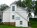
_Church_along_PA_Route_26.jpg)
Emmanuel United Church of Christ
|
|

Map showing Centre County in Pennsylvania
|
|

Jacksonville, Pennsylvania
Location in Pennsylvania

Jacksonville, Pennsylvania
Location in the United States
|
|
| Country | United States |
| State | Pennsylvania |
| County | Centre |
| Township | Marion |
| Area | |
| • Total | 0.14 sq mi (0.37 km2) |
| • Land | 0.14 sq mi (0.37 km2) |
| • Water | 0 sq mi (0.0 km2) |
| Elevation | 902 ft (275 m) |
| Population
(2010)
|
|
| • Total | 95 |
| • Density | 668/sq mi (258.1/km2) |
| Time zone | UTC-5 (Eastern (EST)) |
| • Summer (DST) | UTC-4 (EDT) |
| FIPS code | 42-37545 |
| GNIS feature ID | 2584473 |
Jacksonville is a small community in Pennsylvania, United States. It's known as a "census-designated place," which means it's a special area defined for counting people. You can find Jacksonville in Marion Township, which is part of Centre County, Pennsylvania.
As of the 2010 census, about 95 people lived there.
Exploring Jacksonville's Location
Jacksonville is nestled in a beautiful area called the Little Nittany Valley. It's about 10 miles (16 km) northeast of Bellefonte, which is the main town of Centre County.
Just northwest of Jacksonville, you'll find Howard Gap. This is a pass through Bald Eagle Mountain. A road called Pennsylvania Route 26 goes through this gap, leading about 2.5 miles (4.0 km) to the town of Howard. A major highway, Interstate 80, also passes just southeast of Jacksonville. A new exit, Exit 163, helps people get to Jacksonville and Howard.
Schools in Jacksonville
Students in Jacksonville attend schools that are part of the Bellefonte Area School District.
Gallery
-
Grange

See also
 In Spanish: Jacksonville (condado de Centre) para niños
