Jijel Province facts for kids
Quick facts for kids
Jijel Province
ولاية جيجل
|
|
|---|---|

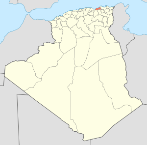
Map of Algeria highlighting Jijel
|
|
| Country | |
| Capital | Jijel |
| Area | |
| • Total | 2,577 km2 (995 sq mi) |
| Population
(2008)
|
|
| • Total | 634,412 |
| • Density | 246.18/km2 (637.61/sq mi) |
| Time zone | UTC+01 (CET) |
| Area Code | +213 (0) 34 |
| ISO 3166 code | DZ-18 |
| Districts | 11 |
| Municipalities | 28 |
Jijel is a special area, like a state or region, in the country of Algeria. It's located right on the eastern coast of the Mediterranean Sea, which is a big ocean. The main city and capital of this area is also called Jijel. You can also find a beautiful place called Taza National Park here!
Understanding Jijel's Sections
Jijel Province is divided into smaller parts to help manage everything. It has 11 main areas called districts and 28 even smaller areas called municipalities or communes. Think of districts as big neighborhoods and municipalities as smaller towns or villages within them.
The Districts of Jijel
Here are the 11 districts that make up Jijel Province:
- Chekfa
- Djimla
- El Ancer
- El Aouana
- El Milia
- Jijel
- Settara
- Sidi Maârouf
- Taher
- Texenna
- Ziama Mansouriah
See also
 In Spanish: Provincia de Jijel para niños
Black History Month on Kiddle
Distinguished African-American Artists:
 | Sharif Bey |
 | Hale Woodruff |
 | Richmond Barthé |
 | Purvis Young |

All content from Kiddle encyclopedia articles (including the article images and facts) can be freely used under Attribution-ShareAlike license, unless stated otherwise. Cite this article:
Jijel Province Facts for Kids. Kiddle Encyclopedia.
