Jolietville, Indiana facts for kids
Quick facts for kids
Jolietville
|
|
|---|---|
|
Town
|
|

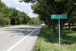
Looking east toward Jolietville along Indiana State Road 32
|
|
| Country | United States |
| State | Indiana |
| County | Hamilton |
| Township | Washington |
| Elevation | 919 ft (280 m) |
| ZIP code |
46074
|
| FIPS code | 18-38844 |
| GNIS feature ID | 437071 |
Jolietville is a small area, or neighborhood, that is now part of Westfield, Indiana. It is located in Washington Township, within Hamilton County, Indiana. Jolietville used to be an independent community. However, in the late 2000s or early 2010s, it officially became part of Westfield. This process is called being "annexed."
Where is Jolietville Located?
Jolietville is found in Indiana at these map coordinates: 40°02′31″N 86°13′52″W. The community is located where two roads meet. These roads are Indiana State Road 32 and Joliet Road. You can find Jolietville just east of the Indianapolis Executive Airport.
Black History Month on Kiddle
Famous African-American Artists:
 | Delilah Pierce |
 | Gordon Parks |
 | Augusta Savage |
 | Charles Ethan Porter |

All content from Kiddle encyclopedia articles (including the article images and facts) can be freely used under Attribution-ShareAlike license, unless stated otherwise. Cite this article:
Jolietville, Indiana Facts for Kids. Kiddle Encyclopedia.

