Jombang Regency facts for kids
Quick facts for kids
Jombang Regency
Kabupaten Jombang
ꦏꦧꦸꦥꦠꦺꦤ꧀ꦗꦺꦴꦩ꧀ꦧꦁ |
||
|---|---|---|
|
Regency
|
||
 |
||
|
||
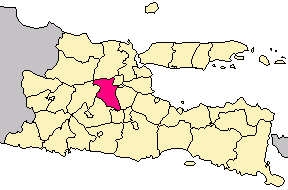
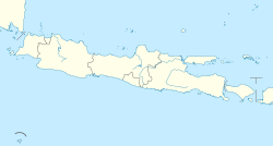
Location within East Java
|
||
| Country | ||
| Province | East Java | |
| Capital | Jombang | |
| Area | ||
| • Total | 1,159.50 km2 (447.69 sq mi) | |
| Population
(mid 2023 estimate)
|
||
| • Total | 1,370,510 | |
| • Density | 1,181.984/km2 (3,061.324/sq mi) | |
| Time zone | UTC+7 (IWST) | |
| Area code | (+62) 321 | |
Jombang Regency is a region in East Java, Indonesia. It's located southwest of a big city called Surabaya. The main town and capital of this regency is also called Jombang.
This area covers about 1,159.50 square kilometers. That's roughly the size of 160,000 football fields! In mid-2023, about 1.37 million people lived here. Jombang became an official regency in 1910. It's famous for being the birthplace of Abdurrahman Wahid, who later became the 4th president of Indonesia.
Exploring Jombang's Districts
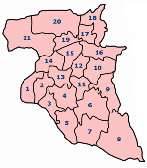
Jombang Regency is divided into 21 smaller areas called kecamatan, which are like districts or sub-regions. Each district has its own administrative center. These districts are made up of many villages. Most are rural villages called desa, but four urban villages called kelurahan are found in Jombang town.
Here's a table showing the districts, their sizes, and how many people live in them:
| District Name | Area (km²) | Population (2023 estimate) | Main Town | Number of Villages |
|---|---|---|---|---|
| Bandar Kedung Mulyo | 32.50 | 52,604 | Banjarsari | 11 |
| Perak | 29.05 | 59,098 | Perak | 13 |
| Gudo | 34.39 | 58,822 | Gudo | 18 |
| Diwek | 47.70 | 114,020 | Diwek | 20 |
| Ngoro | 49.86 | 80,348 | Ngoro | 13 |
| Mojowarno | 78.62 | 99,451 | Mojowarno | 19 |
| Bareng | 94.27 | 59,428 | Bareng | 13 |
| Wonosalam | 121.63 | 35,059 | Wonosalam | 9 |
| Mojoagung | 60.18 | 83,844 | Gambiran | 18 |
| Sumobito | 47.64 | 90,223 | Sumobito | 21 |
| Jogoroto | 28.28 | 74,082 | Jogoroto | 11 |
| Peterongan | 29.47 | 70,502 | Peterongan | 14 |
| Jombang (town) | 36.40 | 143,301 | Jombatan | 20 |
| Megaluh | 28.41 | 41,502 | Megaluh | 13 |
| Tembelang | 32.94 | 57,135 | Pesantren | 15 |
| Kesamben | 51.72 | 68,829 | Kesamben | 14 |
| Kudu | 77.75 | 32,868 | Randuwatang | 11 |
| Ngusikan | 34.96 | 23,768 | Ngusikan | 11 |
| Ploso | 25.96 | 43,430 | Ploso | 13 |
| Kabuh | 97.35 | 43,376 | Karangpaku | 16 |
| Plandaan | 120.40 | 38,820 | Bangsri | 13 |
| Totals | 1,159.50 | 1,370,510 | Jombang | 306 |
The five districts at the end of the table (Kudu, Ngusikan, Ploso, Kabuh, and Plandaan) are in a hilly area made of limestone. The Brantas River separates them from the rest of Jombang. The areas south of the river are mostly flat and great for farming. However, the southeast part, including Ngoro, Mojowarno, Bareng, and Wonosalam, has more mountains.
Jombang's Climate and Weather
Jombang Regency has a tropical climate. This means it's generally warm all year round. The temperatures don't change much from month to month.
| Climate data for Jombang Regency | |||||||||||||
|---|---|---|---|---|---|---|---|---|---|---|---|---|---|
| Month | Jan | Feb | Mar | Apr | May | Jun | Jul | Aug | Sep | Oct | Nov | Dec | Year |
| Mean daily maximum °C (°F) | 33 (91) |
32 (90) |
33 (91) |
32 (90) |
31 (88) |
31 (88) |
30 (86) |
31 (88) |
32 (90) |
33 (91) |
35 (95) |
33 (91) |
32.2 (90.0) |
| Daily mean °C (°F) | 29 (84) |
28 (82) |
29 (84) |
28 (82) |
27 (81) |
27 (81) |
27 (81) |
27 (81) |
27 (81) |
28 (82) |
30 (86) |
29 (84) |
28 (82) |
| Mean daily minimum °C (°F) | 25 (77) |
25 (77) |
25 (77) |
25 (77) |
24 (75) |
24 (75) |
23 (73) |
23 (73) |
22 (72) |
24 (75) |
26 (79) |
25 (77) |
24.3 (75.7) |
| Average rainfall mm (inches) | 223 (8.8) |
221 (8.7) |
198 (7.8) |
237 (9.3) |
147 (5.8) |
181 (7.1) |
37 (1.5) |
20 (0.8) |
5 (0.2) |
29 (1.1) |
80 (3.1) |
280 (11.0) |
138.2 (5.44) |
| Average rainy days | 15 | 10 | 10 | 8 | 7 | 7 | 4 | 0 | 0 | 1 | 8 | 14 | 84 |
| Average relative humidity (%) | 71 | 79.78 | 78.32 | 82.83 | 74.16 | 69.7 | 66.61 | 68.03 | 64.23 | 64.22 | 64.3 | 72.8 | 71.3 |
Jombang experiences a wet season and a dry season. The wet season has a lot of rain, while the dry season has very little.
| Month | Jan | Feb | Mar | Apr | May | Jun | Jul | Aug | Sep | Oct | Nov | Dec | Year |
|---|---|---|---|---|---|---|---|---|---|---|---|---|---|
| Maximum wind speed (km/h) | 58 | 69 | 60 | 48 | 45 | 29 | 60 | 63 | 182 | 138 | 29 | 40 | 68.42 |
| Average wind speed (km/h) | 45 | 48 | 45 | 48 | 42 | 11 | 14 | 14 | 14 | 15 | 11 | 11 | 26.5 |
| Minimum Wind Speed (km/h) | 26 | 29 | 37 | 48 | 40 | 0 | 0 | 0 | 0 | 0 | 0 | 0 | 15 |
| Minimum humidity (%) | 55 | 57.89 | 59.48 | 62.67 | 56.58 | 53.03 | 49.16 | 47.77 | 41.07 | 39.06 | 40.47 | 48.93 | 50.92 |
 | Victor J. Glover |
 | Yvonne Cagle |
 | Jeanette Epps |
 | Bernard A. Harris Jr. |


