
Kakariki railway station facts for kids
Quick facts for kids
Kakariki railway station
|
|||||||||||
|---|---|---|---|---|---|---|---|---|---|---|---|

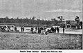
Kakariki railway station and bridge in 1942
|
|||||||||||
| Location | New Zealand | ||||||||||
| Coordinates | 40°07′32″S 175°26′47″E / 40.125543°S 175.446466°E | ||||||||||
| Elevation | 70 m (230 ft) | ||||||||||
| Line(s) | North Island Main Trunk | ||||||||||
| Distance | Wellington 171.21 km (106.38 mi) | ||||||||||
| History | |||||||||||
| Opened | 1879 | ||||||||||
| Closed | 31 January 1982 | ||||||||||
| Electrified | June 1988 | ||||||||||
| Services | |||||||||||
|
|||||||||||
The Kakariki railway station was once an important stop on the North Island Main Trunk railway line. This line runs through the Manawatū-Whanganui region of New Zealand.
The station first opened in 1879. It served the area for many years before closing its doors in 1982. Today, only a single track runs through the old station site. The special "passing loops" that allowed trains to wait for others were moved in 1983. These loops are now at a new spot called Rangitawa, about 2.55 km south.
Contents
History of Kakariki Station
The railway line to Kakariki was built in 1877. It was part of a bigger plan to connect the ports of Foxton and Whanganui. The section from Kakariki to Feilding was built by Nathan & Wilkie.
When the line first opened in 1878, Kakariki wasn't on the train timetable. But soon after, people suggested it needed a goods shed and a loading area. By 1883, it was listed in the fare tables.
By 1892, Kakariki station had a shelter shed for passengers. It also had a platform, a loading bank, and a crane. There was even a passing loop for up to 8 wagons. The crane was removed in 1905. In 1933, a ladies' waiting room was added, but it sadly caught fire that same year. The station yard was rebuilt in 1940 after a new bridge was finished.
In 1980, the station still had a building and a loop for 18 wagons. Kakariki station officially closed to most traffic on January 31, 1982. In 1932, fourteen wagons went off the tracks at the station because an axle broke.
Ballast Pit
In 1889, there was a big need for "ballast" at Kakariki. Ballast is the crushed stone used under railway tracks to keep them stable. By 1892, there was a special siding (a short track) for ballast about 1/4 mile north of the station. This ballast came from pits near the Rangitīkei River.
Kakariki Bridges
The railway line crosses the Rangitīkei River on a large bridge. The current bridge was built in 1939. It's a truss bridge with five long sections. Just upstream, there's another bridge built in 1968 or 1970 for Halcombe Road.
The very first railway bridge was built in 1877. But parts of it were washed away in a flood in June 1882. A temporary bridge was quickly put in place. A new permanent bridge was finished in June 1883. However, this railway bridge was also swept away in another flood in 1897.
From 1900, the bridge was used by both trains and cars. In 1933, a loose part of the bridge hit a train. When the new railway bridge was built in 1939, the old one became a road-only bridge. It was eventually taken down in 1970.
Railway Changes
In 1915, a change was made to the railway line. This "deviation" helped make the climb to Halcombe less steep. It included a new bridge over Rangitawa Stream and a concrete bridge over a deep cutting for Halcombe Road.
Kakariki's Factory
The factory at Kakariki has had many different uses over the years.
- In the early days, there was a sawmill, but it closed in 1879 after all the trees were cut down.
- Around 1882, work started on a flaxmill. Flax from Kakariki was sent by train to Feilding.
Later, a large meat freezing works opened in 1918. It had its own railway sidings for loading meat. This company struggled and closed in 1923. The machinery was removed in 1935. In the 1940s, the factory was used by the Royal New Zealand Air Force for storage. From 1945, it was used to store wool.
In 1948, a company called Feltex took over the factory. They turned it into a plant to clean wool. This plant employed many people. However, Feltex later faced problems and closed the plant in 2006. Another company, Godfrey Hirst, then took over.
In 2007, the site was sold and became the Kakariki Industrial Park. Part of it is now used by Kakariki Proteins. They run a "rendering" plant that turns animal products into animal feed.
St Joseph's Church
About 1.7 km east of where the station was, you can find the small Catholic church of St Joseph. It was built in 1914 for the Ngāti Rangatahi people. The church is a special heritage building in New Zealand.
Near the church, a school opened between 1898 and 1899. It closed in the 1970s.
Images for kids
-
Kakariki railway bridge after 1897 flood
-
Kakariki railway bridge in 2021

