Kangiqtualuk Uqquqti facts for kids
Quick facts for kids Kangiqtualuk Uqquqti |
|
|---|---|
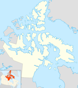
| Location | Baffin Island, Nunavut |
| Coordinates | 70°43′51″N 070°43′53″W / 70.73083°N 70.73139°W |
| Type | Fjord |
| Ocean/sea sources | Baffin Bay |
| Basin countries | Canada |
| Max. length | 110 km (68 mi) |
| Max. width | 19 km (12 mi) |
Kangiqtualuk Uqquqti (pronounced "Kang-ik-too-ah-look Ook-kook-tee") is a long, narrow bay called a fjord. It's found on the northeast coast of Baffin Island in Nunavut, Canada. This area is part of the Arctic. The name Kangiqtualuk Uqquqti comes from the Inuktitut language.
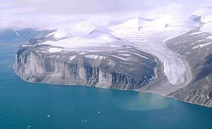
For a while, this fjord was known as Sam Ford Fiord. It's famous for its stunning, rugged scenery. The fjord has tall, rocky cliffs that rise straight up from the water. It's also a very popular spot for climbers who love a challenge.
The nearest Inuit community is Pond Inlet, about 320 km (200 mi) to the northwest. Clyde River is about 80 km (50 mi) to the east.
History of Kangiqtualuk Uqquqti
Kangiqtualuk Uqquqti has always been an important place for the Inuit people. They have traditionally used this area for hunting.
At one point, the fjord was renamed Sam Ford Fiord. This was done to remember Sam Ford, an Inuk linguist who sadly died in a helicopter accident. However, the name has since been changed back to its original Inuktitut name, Kangiqtualuk Uqquqti.
Geography of the Fjord
Kangiqtualuk Uqquqti stretches for about 110 km (68 mi) from north to south. Its entrance, which is the widest part, is over 18 km (11 mi) wide. As you go further inland, the fjord gets narrower. It becomes about 3 km (1.9 mi) wide after about 50 km (31 mi).
Several smaller bays and valleys connect to Kangiqtualuk Uqquqti. For example, Kangiqtualuk Agguqti is another fjord that branches off to the west. The Sam Ford River flows into the very end of the fjord.
Cliffs and Mountains
Kangiqtualuk Uqquqti is well-known for its amazing glaciers and huge granite cliffs. These cliffs rise steeply from the water, reaching heights of up to 1,500 meters (4,900 ft) above sea level. This makes the area very dramatic and beautiful.
Some of the most impressive mountains along the fjord include:
- Beluga Mountain
- Rock Tower
- Walrus Head Mountain
- Broad Peak
- Ottawa Peak
- Sikunga Mountain
- Turnagain Peak
- Paalik Peak
One massive cliff on the eastern side of the fjord is particularly striking. It drops straight down from a height of 1,368 meters (4,488 ft) into the fjord's waters.
See also
In Spanish: Fiordo de Sam Ford para niños
 | Sharif Bey |
 | Hale Woodruff |
 | Richmond Barthé |
 | Purvis Young |


