
Karioi railway station facts for kids
Quick facts for kids
Karioi railway station
|
|||||||||||
|---|---|---|---|---|---|---|---|---|---|---|---|

Karioi railway station on 1966 map
|
|||||||||||
| Location | New Zealand | ||||||||||
| Coordinates | 39°26′51″S 175°30′45″E / 39.447576°S 175.512587°E | ||||||||||
| Elevation | 630 m (2,070 ft) | ||||||||||
| Line(s) | North Island Main Trunk | ||||||||||
| Distance | Wellington 307.14 km (190.85 mi) | ||||||||||
| History | |||||||||||
| Opened | 12 August 1907 | ||||||||||
| Closed | 23 June 1984 | ||||||||||
| Electrified | June 1988 | ||||||||||
| Previous names | Ninia | ||||||||||
| Services | |||||||||||
|
|||||||||||
Karioi was once a busy railway station in the Ruapehu District of New Zealand. It was part of the main railway line called the North Island Main Trunk. Even though the station building is gone, a special section of track called a passing loop is still there. This loop allows trains to wait while another train passes.
Contents
Karioi's Name History
The station's name had a little journey of its own! In 1907, it was briefly called Ninnia or Ninia. But by 1910, it went back to being Karioi. Even so, the name Ninia still appeared on maps as late as 1926. Later, the name Ninia was used again for another railway spot further north. The original Karioi settlement was about 2 miles (3.2 km) south of the station. This area is now known as Karioi Domain.
Station History
Planning for the railway line in this area began in 1894. Workers started clearing the dense bush for the tracks in 1900. The railway tracks reached the Karioi station area by early 1907. The line officially opened for goods trains on 12 August 1907. This connected Karioi to Waiouru and Rangataua.
A road was built to the station in 1907, making it easier to reach. By March 1908, a proper station building was ready. It was a "3rd class station," which meant it had rooms for a stationmaster, luggage, and separate facilities for men and women. The station also had a platform that was 240 feet (73 m) long.
There was a goods shed for storing items, a loading area for trains, and yards for cattle and sheep. Two large water tanks were installed, each holding 4,000 imperial gallons (18,000 litres). The station used special systems like a tablet system and fixed signals to control train movements. Homes for railway staff were built between 1904 and 1919. The crossing loop at Karioi was long enough for 85 wagons. A Post Office operated at the station from 1913 to 1951. The station building was removed in 1971. Karioi station fully closed on 23 June 1984.
Mangawhero Sawmilling Tramway
In 1906, a company called Mangawhero Sawmilling Co. made a deal to cut down trees from a large area of 3,700 acres (1,500 ha). They built a special logging tramway that ran east from Karioi station. This tramway was used between about 1922 and 1929.
Around 1926, the mill bought three special tractors called Nattrass Tractors. They said these tractors "saved the situation" after they had spent a lot of money on a tramway and a locomotive that couldn't move timber because the slope was too steep. An old NZR P class (1876) locomotive was also used on the line from about 1922, but it was taken apart by 1932.
Lake Rotokura
North of where the station once stood, you can find Lake Rotokura and Dry Lake. These are special lakes formed in maar craters, which are like wide, flat volcanic craters. A short walk from the station site leads to Lake Rotokura.
The lake is still surrounded by beautiful beech forest. If you visit, you might spot native New Zealand birds like tūī, kākā, korimako, piwakawka, and toutouwai. Scientists are also keeping an eye on mistletoe plants in the area.
Images for kids
-
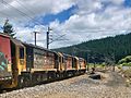
Container train entering Karioi crossing loop from the south
-
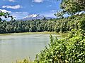
Lake Rotokura and Ruapehu.


