
Karridale, Western Australia facts for kids
Quick facts for kids KarridaleWestern Australia |
|
|---|---|

The Foundry Chimney of the former Karridale Mill in 2021
|
|

Karridale
Location in Western Australia
|
|
| Established | 1884 |
| Postcode(s) | 6288 |
| Area | [convert: needs a number] |
| Location | |
| LGA(s) | Shire of Augusta-Margaret River |
| State electorate(s) | Warren-Blackwood |
| Federal Division(s) | Forrest |
Karridale is a small town in the south-west of Western Australia. It's located between the towns of Augusta and Margaret River. You can find it near Caves Road and Bussell Highway.
A big bushfire in 1961 destroyed the old town. A new Karridale was then built a short distance away. In 2006, about 285 people lived in Karridale. Even though people lived and worked here for many years, Karridale officially became a town only in 1979.
Contents
Karridale's Early History

Karridale started as a place for cutting timber in 1884. A man named M. C. Davies saw that there were many huge Karri trees (Eucalyptus diversicolor) in the area. He thought they would be great for timber.
The Karridale School opened in 1888. At its busiest, about 300 men and their families lived in the town. They worked in the forest and at the M.C. Davies Karri and Jarrah Timber Company mill.
Timber Transport and Decline
The timber from the mill was moved by train to Hamelin Bay. Mr. Davies had built a jetty there to load the timber onto ships. He also had another jetty at Flinders Bay to the south. This second jetty was used when the weather was too rough at Hamelin Bay.
A major storm in 1900 destroyed the Hamelin Bay jetty. Also, people started buying less timber in the early 1900s. Because of this, the timber business slowed down. The last mill in Karridale closed in 1913.
Karridale was also a stop on the train line that ran from Busselton to Flinders Bay. The government ran this train line from the 1920s to the 1950s. Other timber mills in the area included Kudardup, Boranup, and Jarrahdene. Between 1900 and 1914, about 17 million railway sleepers were cut from trees in this region.
The Group Settlement Scheme
In the 1920s, the leader of Western Australia, Premier James Mitchell, started the Group Settlement Scheme. This plan brought British families to Western Australia. The idea was for them to settle and farm undeveloped areas.
One group, called Group 4, came to Karridale. There were about 20 families. Each family received a 160-acre (0.65 km2) piece of land. They also got some money to buy what they needed. However, life was very hard and lonely for these families. Many of them left their farms, especially after the 1929 Depression began. The scheme officially ended in 1930.
The 1961 Bushfires
In 1961, the south-west of Western Australia had terrible bushfires. These fires destroyed the town of Dwellingup. They also completely burned down the town of Karridale. About 100,000 acres of farms, forests, and bushland south of Margaret River were destroyed. In Karridale, even the old home of M.C. Davies was lost in the fires.
Images for kids
-
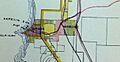
This map from 1899 shows Hamelin Bay and Karridale.

