
Kata Tjuta facts for kids
Quick facts for kids Kata Tjuṯa / Mount Olga |
|
|---|---|
 |
|
| Highest point | |
| Peak | Mount Olga |
| Elevation | 1,066 m (3,497 ft) |
| Prominence | 487 m (1,598 ft) |
| Geography | |

Kata Tjuṯa / Mount Olga
Location in Northern Territory

Kata Tjuṯa / Mount Olga
Location in Australia
|
|

Kata Tjuṯa (which means 'many heads' in the Pitjantjatjara dialect) is a group of large, rounded rock formations. It is also known as The Olgas and officially called Kata Tjuṯa / Mount Olga. These amazing rock domes are found in central Australia, about 360 kilometers southwest of Alice Springs.
Kata Tjuṯa and Uluṟu / Ayers Rock are two famous landmarks. They are both located within the Uluṟu-Kata Tjuṯa National Park. This park is very important and sacred to the local Aboriginal people.
Kata Tjuṯa has 36 domes that spread over an area of 21.68 square kilometers. The rocks are made of a type of sedimentary rock called conglomerate. This means they are made of many different rocks, like granite and basalt, all cemented together by sand. The tallest dome is Mount Olga, which stands 1066 meters above sea level. This is about 546 meters higher than the flat land around it.
Contents
What's in a Name?
The name The Olgas comes from the highest peak, Mount Olga. In 1872, an explorer named Ernest Giles named Mount Olga. He did this to honor Queen Olga of Württemberg. She was a queen from Germany and was born a Grand Duchess of Russia.
Later, in 1993, a new rule was made for naming places. It allowed official names to include both the traditional Aboriginal name and the English name. So, Mount Olga became Mount Olga / Kata Tjuṯa. Then, in 2002, the order was changed. It became Kata Tjuṯa / Mount Olga, which is how we know it today.
How Kata Tjuṯa Formed
The rocks of Kata Tjuṯa and Uluṟu were formed a very long time ago. They are part of a large area called the Amadeus Basin. About 550 million years ago, huge movements in the Earth's crust pushed up mountains. Over millions of years, these mountains wore down. Their pieces of rock and sediment were carried away and deposited in front of the rising mountains. This created the rock layers we see today.
The rocks of Kata Tjuṯa are mostly made of pieces of basalt, granite, and other volcanic rocks. These pieces are held together by a mix of sand and other minerals. Scientists have studied these rocks. They believe they are about 600 million years old.
The rocks themselves are usually a medium to dark gray. Some parts might even have green or pink colors. But Kata Tjuṯa is famous for its bright orange-red color. This color comes from a thin layer of iron oxide (like rust) that covers the rocks.
Ancient Legends and Stories
The Pitjantjatjara people have many ancient stories about Kata Tjuṯa. These stories are part of their Dreamtime beliefs. One legend tells of a powerful snake king named Wanambi. He is said to live on the top of Kata Tjuṯa. It is believed that his breath could turn a gentle breeze into a strong storm. This was to punish those who did wrong.
Many of the stories about Kata Tjuṯa are kept private. They are shared only within the Aboriginal community. The Anangu people believe that the large rocks of Kata Tjuṯa hold special spiritual energy from the Dreaming. Since 1995, the site has been used again for important cultural ceremonies.
Visiting Kata Tjuṯa
You can reach Kata Tjuṯa / Mount Olga by flying to Ayers Rock Airport. From there, it's about a 55-kilometer drive. Visitors need to pay an entry fee to the national park. If you are driving from Alice Springs, it's about a 495-kilometer journey. This drive takes about four and a half hours.
Kata Tjuṯa has special areas for watching the sunrise and sunset. These spots are easy to reach with a short walk from Kata Tjuṯa Road. There are also two main walking trails that let you explore inside the domes:
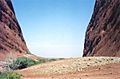
- Valley of the Winds Walk: This walk is 7.4 kilometers long and takes about 3-4 hours. It's considered a moderate to difficult walk.
- Walpa Gorge Walk: This is a shorter walk, about 2.6 kilometers long. It takes 1-2 hours and is easier.

Gallery
-
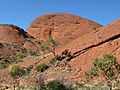
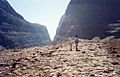
In the Valley of the Winds walk at Kata Tjuṯa / Mount Olga
-
Kata Tjuṯa / Mount Olga
-
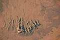
Astronaut photo of Kata Tjuṯa / Mount Olga
-
In Uluṟu-Kata Tjuṯa National Park
-
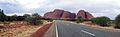
Kata Tjuṯa / Mount Olga, Australia


See also
 In Spanish: Kata Tjuṯa para niños
- Ernest Giles
- Protected areas of the Northern Territory
- Recognition of sacred sites
- Tietkens expedition of 1889
