Keʻanae, Hawaii facts for kids
Quick facts for kids
Keʻanae, Hawaii
|
|
|---|---|
 |
|
| Country | United States |
| State | Hawaii |
| County | Maui |
| Time zone | UTC-10 (Hawaii-Aleutian (HAST)) |
| • Summer (DST) | UTC-9 (HADT) |
| ZIP codes |
96713
|
Keʻanae is a small community located on the island of Maui in the U.S. state of Hawaii. It is an "unincorporated community," which means it's a place with a shared identity but no local government of its own. It's part of Maui County.
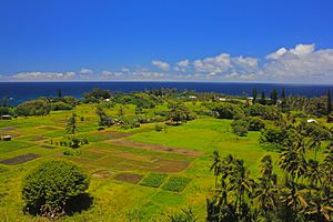
This area is a peninsula, which is a piece of land almost surrounded by water. Keʻanae is famous for its many taro farms. Taro is a plant grown for its starchy root, which is a very important food in Hawaiian culture.
The land that makes up the Keʻanae peninsula was formed by lava flows from the Haleakalā volcano. Today, people from all over the world visit Keʻanae to take beautiful photos and to fish. While the scenery is amazing, it's not safe to swim along the shore. This is because the coastline is made of sharp lava rocks.
Near Keʻanae, there is an old stone church built in 1856. This church is special because it was one of the few buildings that survived a big tsunami in 1946. That tsunami caused a lot of damage and sadly, twenty-four people lost their lives.
Education
The public schools in Hawaii are managed by the Hawaii Department of Education (HIDOE). Students living in Keʻanae usually attend Hana High and Elementary School in the nearby town of Hana.
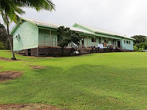
There used to be a local school called Ke'anae School. In 2005, it taught students from Kindergarten to third grade. However, the school was very small, with only about five students on average. In 2005, only three students were enrolled. At the same time, 15 students from Keʻanae were already going to Hana School for grades four through twelve.
To save resources, the Hawaii Department of Education decided to send the remaining students from Keʻanae School to Hana School. After 2005, classes were no longer held at Keʻanae School. It was officially closed in 2010. In 2010, there was also a plan to open a charter school to serve the Keʻanae community.
See also
 In Spanish: Keanae (Hawái) para niños
 | William M. Jackson |
 | Juan E. Gilbert |
 | Neil deGrasse Tyson |


