
Kelvin, Bringelly facts for kids
Quick facts for kids Kelvin |
|
|---|---|
.jpg) |
|
| Location | 30 The Retreat, Bringelly, City of Liverpool, Sydney New South Wales, Australia |
| Built | 1820–1826 |
| Owner | FORM architects (aust) pty ltd |
| Official name: Kelvin; Kelvin Park Group; The Retreat; Thomas Laycock's Cottage Vale; Cottage-ville | |
| Type | state heritage (landscape) |
| Designated | 2 April 1999 |
| Reference no. | 46 |
| Type | Homestead Complex |
| Category | Farming and Grazing |
| Builders | Thomas Laycock |
| Lua error in Module:Location_map at line 420: attempt to index field 'wikibase' (a nil value). | |
Kelvin is a historic home located in Bringelly, near Sydney, Australia. It was built between 1820 and 1826 by Thomas Laycock. This important site is also known by other names like Retreat Farm and The Retreat. It was added to the New South Wales State Heritage Register in 1999 because of its rich history and unique buildings.
Contents
Discovering Kelvin's Past
Early Days and First Owners
The land where Kelvin stands was originally home to Aboriginal people. Clans like the Cabrogal and Murigong lived here for thousands of years. The name "Bringelly" itself comes from an Aboriginal word.
The history of Kelvin Park estate began with several land grants. One large grant of 600 acres went to Thomas Laycock Jr. He was a soldier, explorer, and farmer. In 1824, Laycock sold his 1200-acre "Retreat Farm" to Edward Riley. Soon after, it was sold to John Thomas Campbell. Campbell was an important person, serving as Governor Macquarie's secretary. He was also a successful farmer.
The Australian Agricultural Company
In 1825, a new company called the Australian Agricultural Company (AACo.) leased the farm. This company was formed in London to improve sheep farming in New South Wales. It aimed to grow fine wool for sale. The AACo. was a big deal, becoming a major player in Australia's farming and coal industries. Today, it's the oldest Australian company still operating under its original name!
The company brought many workers and sheep from England. They used "The Retreat" (Kelvin) as a temporary home for their new arrivals. In 1826, most of the company's operations moved to Port Stephens. However, Kelvin continued to be used for grazing animals.
Changes in Ownership
After John Campbell died, the farm was sold many times. In 1833, Alfred Kennerley bought it. He used it as a base for his farming activities. Kennerley later became the Premier of Tasmania.
Over the years, the property changed hands several times. In 1869, William Pearce bought the farm. His family owned "The Retreat" for over 30 years, which was the longest period of ownership at that time.
In 1911, Charles Tyson bought the farm and renamed it "Kelvin." This name has stuck ever since. The farm was likely attractive because it was close to abattoirs (places where animals are processed) in Liverpool.
Kelvin During World War II
From 1942 to 1945, a large part of Kelvin was leased by the Australian government. It was used by the RAAF as a "Dispersal Aerodrome." This meant it was a secret airfield where planes could be hidden if needed during World War II. Even though the airfield was never used for combat, the RAAF made changes to the buildings and cleared some land. After the war, the owner was able to use the land for grazing again.
Kelvin's Modern History
Over time, parts of Kelvin were sold off. In the 1950s and 60s, some land went to the Commonwealth of Australia and the Overseas Telecommunications Commission. By 1982, when the Medich family bought it, Kelvin was about 250 acres.
The property was further divided in the 1980s and 90s. New roads were built, and smaller building lots were created. Today, the historic homestead and farm buildings are on a much smaller piece of land.
Exploring Kelvin's Buildings and Grounds
.jpg)
The Kelvin Park Group includes several old buildings and interesting features:
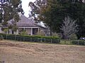
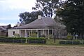
- The homestead is the main house. It's a single-story brick bungalow built in the Colonial Georgian style. It has a classic hipped roof and a wide veranda.
- The kitchen is a separate building next to the main house. It might have been the original homestead.
- There are also servants' quarters and a dairy.
- The Coach House is a brick building with a loft. It was used for coaches, stables, and even as a lock-up.
- Two slab timber sheds show how farming was done long ago.
- The gardens, trees, and driveways are also important parts of the site.
- You can also find old relics like a cellar, a water tank, and a horse sweep.
The Homestead's Design
.jpg)
The Kelvin homestead is a beautiful example of a Georgian farmhouse. It has a stucco (plaster) finish and a hipped iron roof. A wide veranda surrounds three sides of the house, paved with sandstone. The front door has a lovely elliptical fanlight (a window above the door shaped like a fan). Inside, you can see amazing cedar woodwork.
Gardens and Trees
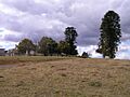
Kelvin's main buildings are on a small hill, offering nice views. The garden has been updated over the years, but it still has many important old trees. A circular driveway in front of the house, around a large fig tree, is a reminder of the original carriage loop.
Some of the oldest and most valuable trees include hoop pines, brown pines, and Canary Island pines. Two large camphor laurels stand proudly, framing the view from the front door. Other interesting plants include old olive trees, cypress, and a lemon-scented gum.
The main garden is surrounded by a timber and wire fence. The way you enter the property today is different from how it was in the past.
Why Kelvin is Important
.jpg)
Kelvin Park is very important because it shows how farming developed in Bringelly from 1818 onwards. Even though the property is much smaller now, the homestead and farm buildings still show what a 19th-century farm estate looked like.
Kelvin is connected to many important people and groups in New South Wales history. This includes Thomas Laycock Jr., who started the farm, and later owners like John Thomas Campbell and Alfred Kennerley. The fact that the Australian Agricultural Company, one of Australia's oldest farming companies, leased the property, makes it even more special.
The homestead at Kelvin is a great example of a gentleman's country home from the 1820s. Its design and original features are still clear, even with some changes. The kitchen wing and servants' quarters also show early colonial architecture. The brick coach house is a good example of early Victorian style.
The two old slab barns show how farming was done at Kelvin from its very beginning until the mid-20th century. These buildings teach us about 19th-century building methods and farm life.
The buildings at Kelvin are part of a rare group of colonial farm buildings. They show that the land has been used for farming for over 187 years! The gardens, courtyards, and entry areas also tell us about how the property was planned and used by its owners.
Kelvin Park also has important historic views. You can see Thompson's Creek and South Creek, which helps you imagine what the landscape was like long ago. The old trees also make the site a notable landmark in the area.
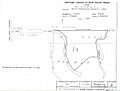
Kelvin was officially listed on the New South Wales State Heritage Register on April 2, 1999, recognizing its great historical value.
Images for kids
-
Kelvin Homestead, main image
-
Landscape view of Kelvin
-
Close-up of the Homestead
-
Map showing Kelvin's heritage boundaries
