Kenton Vale, Kentucky facts for kids
Quick facts for kids
Kenton Vale, Kentucky
|
|
|---|---|

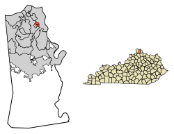
Location of Kenton Vale in Kenton County, Kentucky.
|
|
| Country | United States |
| State | Kentucky |
| County | Kenton |
| Incorporated | 1949 |
| Named for | Kenton County |
| Area | |
| • Total | 0.05 sq mi (0.14 km2) |
| • Land | 0.05 sq mi (0.14 km2) |
| • Water | 0.00 sq mi (0.00 km2) |
| Elevation | 535 ft (163 m) |
| Population
(2020)
|
|
| • Total | 105 |
| • Density | 1,944.44/sq mi (757.64/km2) |
| Time zone | UTC-5 (Eastern (EST)) |
| • Summer (DST) | UTC-4 (EDT) |
| ZIP code |
41015
|
| Area code(s) | 859 |
| FIPS code | 21-42094 |
| GNIS feature ID | 2404823 |
Kenton Vale is a small city in Kenton County, Kentucky, in the United States. It's known as a "home rule-class city." This means it has the power to manage its own local affairs. In 2020, about 105 people lived there.
Kenton Vale is a very small place. It has just one neighborhood and a cemetery. You can only get in and out of the city from one intersection. That intersection is where Kuhrs Lane meets Madison Pike (Kentucky Route 17). The city was named after Kenton County. The county itself got its name from a famous explorer, Simon Kenton.
The city was officially created in 1949 by the state government. Its main purpose was to stop the larger city of Covington from taking over homes in the area.
Contents
Where is Kenton Vale?
Kenton Vale is located in Kenton County, Kentucky. Its exact location is 39°3′5″N 84°31′12″W / 39.05139°N 84.52000°W. The United States Census Bureau says the city covers about 0.1 square miles (0.14 square kilometers). All of this area is land.
How Many People Live Here?
| Historical population | |||
|---|---|---|---|
| Census | Pop. | %± | |
| 1950 | 165 | — | |
| 1960 | 168 | 1.8% | |
| 1970 | 178 | 6.0% | |
| 1980 | 145 | −18.5% | |
| 1990 | 358 | 146.9% | |
| 2000 | 156 | −56.4% | |
| 2010 | 110 | −29.5% | |
| 2020 | 105 | −4.5% | |
| U.S. Decennial Census | |||
In 2000, there were 156 people living in Kenton Vale. These people lived in 57 households, and 44 of those were families. The city had about 2,694 people per square mile. There were 59 housing units in total.
Most of the people living in Kenton Vale in 2000 were White (100%). About 28% of households had children under 18 living with them. Most households (70%) were married couples.
The average household had about 2.74 people. The average family had about 3.13 people.
Age Groups in Kenton Vale
The population in 2000 was spread out by age:
- 23.1% were under 18 years old.
- 9.0% were from 18 to 24 years old.
- 29.5% were from 25 to 44 years old.
- 23.7% were from 45 to 64 years old.
- 14.7% were 65 years or older.
The average age in the city was 38 years. For every 100 females, there were 100 males.
Education
Children in Kenton Vale go to school in two different districts. Some parts of the city are in the Kenton County School District. Other parts are in the Covington Independent School District.
See also
 In Spanish: Kenton Vale (Kentucky) para niños
 | Percy Lavon Julian |
 | Katherine Johnson |
 | George Washington Carver |
 | Annie Easley |

