Ketchuptown, South Carolina facts for kids
Quick facts for kids
Ketchuptown, South Carolina
|
|
|---|---|

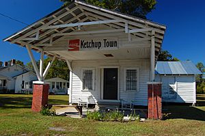
Country store at the crossroads
|
|
| Country | United States |
| State | South Carolina |
| County | Horry |
| Established | 1920s |
| Area | |
| • Total | 2.71 sq mi (7.02 km2) |
| • Land | 2.71 sq mi (7.02 km2) |
| • Water | 0.00 sq mi (0.00 km2) |
| Elevation | 64 ft (20 m) |
| Population
(2020)
|
|
| • Total | 84 |
| • Density | 31.00/sq mi (11.97/km2) |
| Time zone | Eastern |
| ZIP Code |
29581 (Nichols)
|
| Area code(s) | 843 |
| FIPS code | 45-38110 |
Ketchuptown is a small, historic community in Horry County, South Carolina, United States. It's known as an "unincorporated community," which means it doesn't have its own local government like a city or town. It's also a "census-designated place" (CDP), which is an area the U.S. Census Bureau defines for gathering population data.
Ketchuptown is located where two highways meet: Highway 23 and Highway 99. It's about 9 miles (14.5 km) north of a town called Aynor. According to the 2020 census, only 84 people lived there, making it a very tiny place!
The Story Behind Ketchuptown
Ketchuptown started as a small farming community. It became well-known in the 1920s. Farmers in the area would often say, "Let's go catch up on the news!" This was their way of saying they were going to meet up and chat.
Every Saturday afternoon, these farmers would gather at a little country store in Ketchuptown. This store was the main meeting spot. It was where everyone could share stories and catch up on what was happening. That's how the community got its unique name!
Where is Ketchuptown?
Ketchuptown is easy to find because it sits right at the crossroads of two important highways.
- Highway 99 goes east about 16 miles (25.7 km) to Loris.
- Highway 99 also goes southwest about 8 miles (12.9 km) to Galivants Ferry.
- Highway 23 goes south about 10 miles (16.1 km) to Cool Spring.
These roads connect Ketchuptown to other nearby towns and communities in Horry County.
People in Ketchuptown
The United States government counts how many people live in different places every ten years. This count is called a census. The latest census in 2020 showed that Ketchuptown has a population of 84 people.
Ketchuptown is a small community with a mix of people. Most residents are White, making up about 75% of the population. There are also people of Native American heritage and a significant number of people who identify as Hispanic or Latino. This shows that even in small places, communities can be diverse!
 | Frances Mary Albrier |
 | Whitney Young |
 | Muhammad Ali |


