King Archaeological Site facts for kids

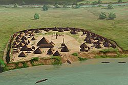
Artist's conception of the King Site
|
|
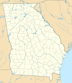
| Location | Rome, Georgia, Floyd County, Georgia, |
|---|---|
| Region | Floyd County, Georgia |
| Coordinates | 34°11′53.3″N 85°23′48.19″W / 34.198139°N 85.3967194°W |
| History | |
| Founded | Early sixteenth century |
| Abandoned | Late sixteenth century |
| Periods | Barnett Phase |
| Cultures | South Appalachian Mississippian culture |
| Site notes | |
| Excavation dates | 1992, 1993 |
| Archaeologists | David Hally |
| Architecture | |
| Architectural styles | village, plaza, council house |
| Responsible body: private | |
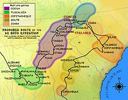
The King Archaeological Site (also known as 9FL5) is a very old Native American village site. It's located in Floyd County, Georgia, right by the Coosa River. This site was one of about five large villages that existed around the same time in that area. It was a smaller village connected to the main Coosa chiefdom, which was centered at the Little Egypt Site further upstream.
Contents
Exploring the King Site Village
The King Site was a village covering about 5 acres (20,000 square meters). It was built on the eastern bank of the Coosa River in the mid-1500s. The village had a square shape, measuring about 149 meters (489 feet) on each side.
Village Layout and Defenses
The village was protected by a ditch and a tall fence called a palisade on three sides. The Coosa River protected the fourth side. In the middle of the village was a large open area called a plaza. A huge post, almost 1 meter (3 feet) wide, stood in the center of this plaza. It was probably 6 to 10 meters (20 to 33 feet) tall.
Between the plaza and the palisade, there were about 47 houses. There were also several raised storage buildings for maize (corn).
Homes of the Villagers
The houses at the King Site were shaped like rectangles with rounded corners. Their floors were dug into the ground, about 30 to 50 centimeters (12 to 20 inches) deep. The dirt from these holes was piled up around the outside walls.
These homes were built using a method called wattle and daub. This means they used woven branches (wattle) covered with a mix of mud, clay, and straw (daub). The roofs were likely peaked and covered with thatch. Each house was quite large, averaging about 60 square meters (646 square feet).
Inside the houses, four strong posts supported the roof in a central square. Smaller wattle and daub walls divided the space into different areas. These areas were used for working, storing things, and sleeping.
Keeping Homes Dry and Food Safe
The entrances to the houses had low raised walls. These walls probably helped keep water, dirt, and other things from washing into the sunken floors during rainy weather.
The elevated corn cribs (storage buildings) stood about 2 meters (6.5 feet) off the ground. These were used to store food like corn. They also created shady spots underneath, which would have been nice for activities during hot summer days. Archaeologists think these two types of structures might have been used for different seasons. Perhaps the dugout houses were for winter, and the open areas under the corn cribs were for summer.
Family and Community Spaces
Often, two or three winter houses and their summer outdoor areas were grouped around a small central courtyard. This suggests that larger families, perhaps extended families, lived together in these groups. This arrangement was similar to how the whole village was set up, with houses grouped around the main plaza.
Special Buildings and Population
In the northeast part of the plaza, there were two special buildings. One, called structure #17, was a square building about 15 meters (49 feet) on each side. It had benches inside. Archaeologists found the remains of ten adult males buried under its floor. This building was likely a meeting place or a council house for the community.
The second special building, structure #16, was smaller. Its exact purpose is still a mystery to archaeologists. Experts believe that between 277 and 517 people lived in the King village.
Since the village was only lived in for about 50 years, the people didn't build huge platform mounds. These large mounds were often built over many generations at bigger Mississippian culture sites that were occupied for much longer periods.
History of the King Site
The King Site was first settled in the early 1500s. At first, there were only a few homes. Over the next ten years, as the town grew, the people planned out their village. They created a defensive border, the central plaza, and areas for homes. The village seems to have had a clear plan from the very beginning, a pattern seen in other similar settlements nearby. After about 20 to 30 more years, the town was abandoned.
European Visitors and Their Impact
During the time the King Site was active, two famous Spanish expeditions passed through the area. These were led by Hernando de Soto in 1540 and Tristan de Luna in 1560. It's very likely that one of these groups visited the King Site.
Archaeologists found many European items during their digs, such as iron tools. It's not completely clear why the site was abandoned. Some evidence from graves suggests that a widespread illness affected the people. However, archaeologists have different ideas about how big of a role this played in the village being left empty.
Archaeological Digs
The King Site was carefully excavated in 1992 and 1993. The work was led by David Hally from the University of Georgia and Patrick Garrow from Shorter University in Rome, Georgia.
 | Jewel Prestage |
 | Ella Baker |
 | Fannie Lou Hamer |


