King William Range facts for kids
Quick facts for kids King William Range |
|
|---|---|

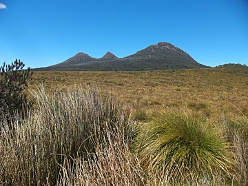
Three peaks of the King William Range seen from the Lyell Highway
|
|
| Geography | |
| Country | Australia |
| State | Tasmania |
| Region | South West Wilderness |
The King William Range is a group of mountains in Tasmania, Australia. It is located in a wild and beautiful area known as the South West Wilderness. This mountain range is very important because it is where the Gordon River begins its journey.
Discovering the King William Range
The King William Range is found south of the Lyell Highway and the small town of Derwent Bridge. This region is famous for its rugged landscapes and untouched nature. It's a place where you can truly experience the wild side of Tasmania.
For a long time, people thought the King William Range had only one main peak. However, it actually has three distinct peaks. These peaks are known as Mount King William I, II, and III. Each one stands tall in this impressive mountain range.
Tallest Peaks in the Range
Several mountains in the King William Range reach heights of over 1,100 meters (about 3,600 feet). These high peaks offer amazing views of the surrounding wilderness. Some of the tallest include:
- Loddon Bluff (1,220 meters)
- Mount King William I (1,324 meters)
- Slatters Peak (1,300 meters)
- Mount King William II (1,363 meters)
- Mount Hobhouse (1,222 meters)
- Wentworth Hills (1,244 meters)
Location and Waterways
The King William Range is sometimes considered part of Tasmania's Central Highlands region. It is also close to large water storage areas created by Hydro Tasmania. These areas are important for generating electricity using water power. The range plays a key role in the water system of this part of Tasmania.
 | Misty Copeland |
 | Raven Wilkinson |
 | Debra Austin |
 | Aesha Ash |

