Kistler, West Virginia facts for kids
Quick facts for kids
Kistler, West Virginia
|
|
|---|---|

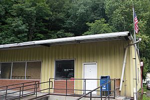
Kistler post office
|
|
| Country | United States |
| State | West Virginia |
| County | Logan |
| Area | |
| • Total | 1.494 sq mi (3.87 km2) |
| • Land | 1.486 sq mi (3.85 km2) |
| • Water | 0.008 sq mi (0.02 km2) |
| Elevation | 774 ft (236 m) |
| Population
(2010)
|
|
| • Total | 528 |
| • Density | 355.3/sq mi (137.2/km2) |
| Time zone | UTC-5 (Eastern (EST)) |
| • Summer (DST) | UTC-4 (EDT) |
| ZIP Code |
25628
|
| Area code(s) | 304 & 681 |
| GNIS feature ID | 1541251 |
| FIPS code | 54-44188 |
Kistler is a small community located in Logan County, West Virginia, in the United States. It's known as a "census-designated place" (CDP). This means it's an area that the government counts as a separate place for population statistics. However, it doesn't have its own local government like a city or town. In 2010, about 528 people lived in Kistler.
Where is Kistler Located?
Kistler is found in the southern part of Logan County. It is about 1.5 miles (2.4 kilometers) northeast of a town called Man. The community sits along a waterway known as Buffalo Creek. To its northeast, you'll find the community of Accoville.
Land and Water Area
According to the U.S. Census Bureau, the Kistler CDP covers a total area of about 1.494 square miles (3.87 square kilometers). Most of this area, about 1.486 square miles (3.85 square kilometers), is land. A small part, about 0.008 square miles (0.021 square kilometers), is water. This means water makes up about 0.54% of Kistler's total area.
The Buffalo Creek Flood
In 1972, Kistler was one of the communities affected by the Buffalo Creek flood. This event was a major disaster that impacted many areas along Buffalo Creek.
See also
 In Spanish: Kistler (Virginia Occidental) para niños
 | Mary Eliza Mahoney |
 | Susie King Taylor |
 | Ida Gray |
 | Eliza Ann Grier |


