Kjerulf Glacier facts for kids
For the glacier in Svalbard, see Kjerulfbreen. For the glacier in Jan Mayen, see Kjerulf Glacier (Jan Mayen).
Quick facts for kids Kjerulf Glacier |
|
|---|---|
| Location | South Georgia |
| Coordinates | 54°21′S 36°51′W / 54.350°S 36.850°W |
| Length | 7 nmi (13 km; 8 mi) |
| Thickness | unknown |
| Terminus | Newark Bay |
| Status | unknown |
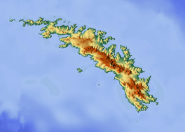
Kjerulf Glacier, Norwegian: Kjerulfbreen, (54°21′S 36°51′W / 54.350°S 36.850°W) is a glacier 7 nautical miles (13 km) long flowing west from Mount Sugartop to the east side of Newark Bay, on the south coast of South Georgia. It was mapped by Olaf Holtedahl during his visit to South Georgia in 1927–28, and named by him for Norwegian geologist Theodor Kjerulf, Professor of Mineralogy at the University of Christiania.

All content from Kiddle encyclopedia articles (including the article images and facts) can be freely used under Attribution-ShareAlike license, unless stated otherwise. Cite this article:
Kjerulf Glacier Facts for Kids. Kiddle Encyclopedia.

